This day we returned to the Quebradas Back Country Byway, having visited Ojo de Amado 3 weeks earlier. ‘Twas our plan to drive further south on the Byway, and find our way to “Singing Rock” in Arroyo del Tajo. A friend Lanny had told us about it, and after some research we located on GoogleEarth. And finding a great article by the geocaching folks, we chose the approach to Singing Rock from the east, a 2 mile hike down down the Arroyo from the Byway.
The Drive In
I described the drive in on the post for the Ojo de Amado Hike; I’ve included some photos in the gallery below of signs along the way. (But you probably won’t see the longhorn when you head that way.) Just as the Byway approaches Arroyo del Tajo, we found a nice parking area to the right.
The Hike
Donning our packs, we proceeded down the wash in the bottom of the Arroyo. It was mostly large particle sand interspersed with rocks. About a mile in we came upon an old rock building – ’tis interesting to imagine when and for what it was used. From there we departed the wash for higher ground – a ridge that gave us quite a view in all directions. It was also a fine spot to break for the first half of our lunch.
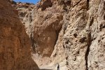
We continued on the ridge and soon could see the narrowing of the Arroyo where we suspected we would find Singing Rock. We descended back into the wash and entered a cañon that amazed us. Passing through the entrance we found ourselves in a huge gallery, very high vertical walls, only a few yards wide – top and bottom of the cañon sides. We continued through the canyon looking for holes in the walls; there were many but most were high above the wash. Near the end, we found a few, two of which were at a height we could stick your heads into them. I tested each with my limited range of ‘musical notes’, and think a note low in my range seemed to be amplified by the cavity. Matching my photo with one from Lanny, I conclude – these were the Singing Rocks.
We decided to take a different route back to the truck, to take a different arroyo back to the Byway. Much like Arroyo del Tajo, the wash was sand with rock – not difficult walking. And for some stretches we would walk up on the banks where the surface was harder and smoother. Nearing the Byway, we turned into a small side canyon, then cross country to the Byway and back to the truck, where we had our 2nd half lunch on the tailgate. Another great hike in this Land of Enchantment.
Statistics
Total Distance: 5.3 miles
Elevation: start 5,133 ft, maximum 5,198 ft, minimum 4,904 ft
Gross gain: 194 ft. Aggregate ascending 746 ft, descending 746 ft
Maximum slope: 50% ascending, 27% descending, 4.0% average
Duration: 6:05
| GPS Track Files for Download | |
149 Downloads |
|
|---|---|
146 Downloads |
|

