
I typically bring the following:
- A backpack with the following:
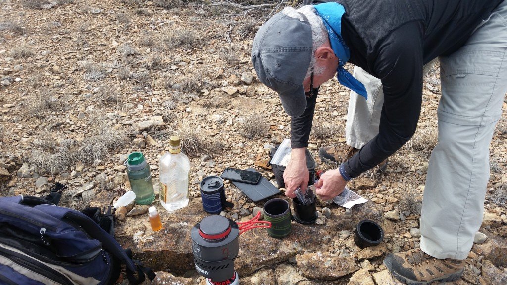
- A 1.5 liter gin bottle, … filled with WATER. (These bottles have a convenient shape and are quite durable)
- One or two drinking bottles for use while on the trail
- A Primus ETA Express butane stove and a canister of fuel
- Two GSI camp cups plus small bottles of ‘additives’ for the coffee (whiskey or brandy or whatever I fancy that week)
- A reusable coffee filter & some freshly ground coffee (Jay brings the coffee)
- A small ground cloth to use as our “table”
- Some snacks for the mid-hike break: between us we have some sort of trail mix, some granola bars, maybe some fruit, and always peanut butter crackers
- A few paper towels and plastic bags, plus toilet paper
- A pack of first aid supplies including sun screen
- Oh, and a small backpacking shovel and paper towels, for you-know-what
- For navigating and recording our tracks:
- “Years ago” I began hiking with a DeLorme PN-60. But since then, the smartphone has become my ‘go-to’ device for navigating and tracking. I can do more with the Smartphone and it is much easier to use, oh and the map display is much larger.
- I’ve gone through 3 Smartphone devices; now I carry a Samsung Galaxy S10.
- After working with a couple other Android apps for the Smartphone (Maverick, for example), I discovered US Topo Maps from ATLOGIS. See my Nifty/Essential Tools page for more information.
- UPDATE: My go-to GPS app is now GAIA GPS. I can use it on my Android phone and on the web (GAIAGPS.com) and … they provide an app for IOS/iPhone so Pat & Jay can share.
- Prior to the hike or other adventure:
- I will collect GPS data from the Web: road routes to the trailhead if needed, tracks for the hike, and any waypoints that may be helpful
- Here are some of the resources that I use most:
- Nearly all the trails and associated waypoints in the Sandia Mountains are available from the online companion to the Sandia Mountain Hiking Guide.
- The the Albuquerque Senior Center Hiking Groups (ASCHG),is a tremendous source for hikes/trails throughout central New Mexico. And they provide .gpx files for download to be used with GPS devices. See my “Using Google Earth Track Files” for information on using .gpx, .kml, Gand other types of GPS files.
- Other resources include National Park Service, US Forest Service, BLM, AllTrails, SummitPost, and web sites of many organizations and individuals. You can see many more in the “References and Resources” section of each BLOG post.
- Wherever I can find records of others who have made hikes, then I will down load GPS tracks if available (.kml or .gpx).
- In the absence of these resources, and when we have chosen a destination such as a pueblo ruins site, I will guestimate the best track from the nearest parking spot to the destination using GoogleEarth. Then create a route and save the .kml.
- Or use a GPS track from a previous hike/adventure of ours.
- Here are some of the resources that I use most:
- These I will load the file or files into GAIA or US Topo, ready to assist in navigating for the adventure.
- VERY IMPORTANT: I also load the appropriate map tiles into GAIA (or US Topo) so that I have off-line access to the map for the hike.
- For GAIA, I’ve come to prefer the “GAIA Hike (feet)” overlay; there are numerous others, including even “Satellite”.
For US Topo, I prefer the “Scanned Topo Maps USA dynamic” maps from among the half dozen or so that are available.
- For GAIA, I’ve come to prefer the “GAIA Hike (feet)” overlay; there are numerous others, including even “Satellite”.
- I will collect GPS data from the Web: road routes to the trailhead if needed, tracks for the hike, and any waypoints that may be helpful
- And I bring a compass and occasionally a printed map (‘tho the GPS and the cellphone are preferred as those devices typically have greater detail and track our position real-time)
- “Years ago” I began hiking with a DeLorme PN-60. But since then, the smartphone has become my ‘go-to’ device for navigating and tracking. I can do more with the Smartphone and it is much easier to use, oh and the map display is much larger.
- My companions bring additional stuff to meet their needs and to share:
- Jay brings in his backpack:
- Poncho
- Bandanas
- Extra socks
- Extra tee
- Gerber Crucial multi-tool
- Drinking water
- Plastic spoons
- Raw sugar
- Sunscreen
- Butane lighter
- Prescription strength ibuprofen
- Powergen auxiliary power supply for iPhone
- iPhone case that belt inserts thru (prevents phone from popping off belt clip and making us go back to find it)
- Ben’s bug repellent wipes
- Tweezers (anti prickly pear tool)
- Coffee
- His favorite trail mix of the week
- An iPhone with the
GPS Motion XGAIA GPS app for navigating, recording our tracks, and taking great photos.
- Jay brings in his backpack:
To date: 129 views.