Dragon Back Hike.Vince.2016-02-16.jpg
Introduction
White Mesa is a mesa of white gypsum west of Albuquerque; it is catches the eyes of anyone traveling west on US 550 from Bernalillo. Dragon’s Back is is a very interesting formation south of White Mesa, used extensively by bikers because the surface is relatively smooth (i.e. it isn’t rocky).
The Hike
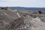
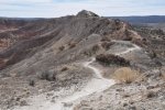
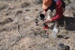
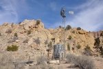
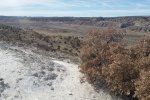
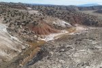
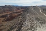
Vince and I set out to make the shorter hike, but missed a turn and walked the length of the “Dragon’s Back”. The trail out is atop the ridge which is at times quite narrow. All along fthe ridge one is looking down to the east into a large canyon or bowl about 300 feet deep, about 2/3 miles across. At the far end, we descended to the west onto a 2-track (auto) trail, took some time out for refreshments, then returned to the parking area. On the way, we came across a windmill in the shadow of Dragon’s Back, and behind the windmill in the cliff face 3 alcoves with crosses in them, a curiosity. This makes a great fall to spring hike; with no trees for cover, it will be quite hot in the summer.
Statistics
Total Distance: 6.1 miles
Elevation: start 5,831 ft, maximum 5,980 ft, minimum 5,606 ft
Gross gain: 374 ft. Aggregate ascending 863 ft, descending 863 ft
Maximum slope: 25% ascending, 32% descending, 3.4% average
Duration: 4:31
| GPS Track Files for Download | |
260 Downloads |
|
|---|---|
225 Downloads |
|
I urge you to explore our hiking tracks with Google Earth. With the virtual 3-dimensional presentation, achieved by panning and tilting the view, you can get a much better idea of the hikes and terrain than you can get from the 2-dimensional screenshot above. For assistance: Using Google Earth Track Files.
References
Travels with the Blonde Coyote: Best Hikes on Earth: The Dragon’s Back
Tourism Santa Fe: White Ridge Bike Trails


