Today we explored another of the areas we thought would be interesting on the mesa south of Cabezon Road (see Ojito Mesa/South Hike). Striking out on our own, to explore an area that looked interesting via GoogleEarth. Mesa Prieta is in the background, with Mount Taylor and Chivato Mesa on the horizon.
The Hike
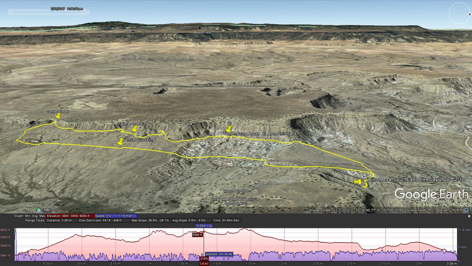
Ojito Mesa-SouthEast Hike.Jay.2017-02-19
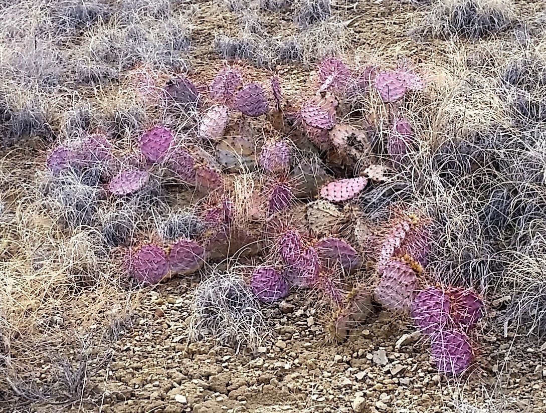
Flora for this hike: Prickly pear catus in it’s winter colors.
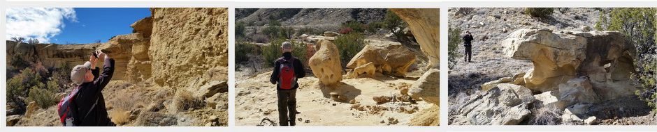
Leaving the road on a two-track, we proceeded on somewhat rough terrain until prudence said “far enough”. Then walking up the tortured two-track and cresting the rise, a wide open plain lay before us, with the mesa as a backdrop. Approaching the face of the mesa, we decided to follow along heading south. Soon we found ourselves in an area of amazing rock formations – colors, shapes, textures, and more. As can be seen from our speed (the blue area on the profile graph on GoogleEarth image), from the .5 mile point until .8 mile, we spent a lot of time marveling at the rocks and terrain in this area. This definitely made this a great hike.
We continued south along the face of the mesa, looking for an area where we might ascend to the mesa top – none presented itself (although another .25 mile or so a canyon extending into the mesa appeared to offer such an opportunity). Along the way we had to slide under another fence, much as was required on the Ojito Mesa/South hike (I suspect this is another section of the same fence line.)
The weather alternated between sunny and warm, and cloudy, breezy, and cool; we found a protected area up near the mesa side for our coffee break. We watched a rain/snow squall move across north of us, further than where we parked the truck, but uncertain of its path we headed back across the grassy plain. Nearing the place where the truck was parked, Mother Nature visited us with drizzle that turned to snow pellets, just enough to get us damp. And enough to wet the two-track so the clay was becoming slick – we were happy to get out before it became unmanageable (happy to have 4-wheel drive, too).
Jay here: There are two simple reasons we keep going back to the Ojito Wilderness. Number 1 is the incredible geology of the place. There’s endless variety to marvel at and it always comes with some amazing backdrops. Number 2, we’ve barely scratched the surface of possible known trails and unknown trails. Number 3 (even though I said there were 2 reasons), the time to go is now. Summer will be too hot. Which brings me to the wicked sleet storm that descended on us during the last quarter mile of our hike. Only in New Mexico could a storm like that come up so fast and then stall over the top of us. It made for a slippery escape from an already hairy two-track, and yes, thank you 4-wheel drive.
Statistics
Total Distance: 3.27 miles
Elevation: 5,843 start, 6,038 maximum, 5,843 minimum
Gross gain: 195 ft. Aggregate ascending 475 ft, descending: 475 ft
Maximum slope: 38% ascending, 33% descending, 6% average
Duration: 3:00
| GPS Track Files for Download | |
280 Downloads | |
|---|---|
171 Downloads | |
I urge you to explore our hiking tracks with Google Earth. With the virtual 3-dimensional presentation, achieved by panning and tilting the view, you can get a much better idea of the hikes and terrain than you can get from the 2-dimensional screenshot above. For assistance: Using Google Earth Track Files.
Related Posts (in the vicinity)


