I joined Jay in Santa Fe for a hike on a nearby trail. We hiked Aspen Vista back in 2018, but for this hike we chose to start where Tesuque Creek crosses SR 475.
The Drive In
Quite straightforward: drive up SR 475, also known as Hyde Park Road. Little Tesuque Creek crosses 475 4.3 miles from the Hyde memorial State Park main entrance. There is parking on the right of the road for a few cars.
The Hike
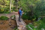
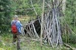
The trail proceeds up the North Fork of Tesuque Creek, identified on a sign as Big Tesuque Tr 152. The trail here is well used and easy going – a couple of hundreds yards along it crosses over a nice bridge to the north side of the creek and continues uphill at about a 10% grade.  Along the way we saw a number of what appeared to be shelters, lean tos of a long branch leaning against a tree with many smaller straight branches leaning into it – curious.
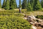
At .8 miles, the trail intersects a jeep trail, Forest Road 150 (which takes one to the communications facility atop the mountain). Rather than turn right on the road (and follow the route of our previous hike), we chose to continue up Tesuque Creek.  Wow, that was some choice – the grade quickly became much steeper (20%, 30%) and became more rocky and with tree roots. But the forest is healthy making the surroundings quite pleasant – aspen, fir, pine, and along the way a burbling creek. The going became really tough 1.4 miles into the hike, when the grade increased to a steady 40%. Nearing the top of what appeared to be a ridge, the forest opened up to a few conifers
  with a blanket of small shrubs covering the area. At the top of that section (1.7 miles on) we entered a cleared area that must be part of the ski runs of Santa Fe Ski Basin. The views were great, despite the haze that has settled in over New Mexico in recent days.
 At this point, we debated – turn back retracing our route down or continue up the cleared area another .3 mile, and 450 feet, where we could get on the upper end of FR 150 and have an easier although longer return to the trailhead. Being uncomfortable with descending the steep, rough trail we had taken to this point, we opted to go for FR 150 despite it being 5 miles (vs 2 miles to the trailhead if we retraced our route up). So we climbed those 450 feet, then headed down the jeep trail.
Back to easy walking, we relaxed (and recovered) from the strenuous ascent. About 3/4 of a mile on, we avoided a lengthy loop by bushwhacking downhill, thus saving about half a mile.  Not far past that point we realized that we had come upon the ridge and lookout where we had our lunch break on the previous Aspen Vista hike – it brought back more memories .. of another challenging hike for us. From there it was an easy downhill hike back to the trailhead (‘tho Jay was looking for something easier).
Jay here: Holy mother of all steep trails! Following the spring that runs down to the Aspen Vista trail was a pleasure. It lulled us into thinking this was the way it was going to be all the way up. Nope. When we got to the big ski hill, we could only go about 50 feet and then stop to get our wind back. A 40% grade is challenging to say the least. This hike was a major workout.
Highlight
A highlight? Probably — that we -did- it, for us a long and strenuous hike the likes of which we haven’t done in some time.
Statistics
Total Distance: 6.95 miles
Elevation: start 9,670 ft, maximum 11,826 ft, minimum 9,670 ft
Gross gain: 2,156 ft. Aggregate ascending 2,350 ft, descending 2,346 ft
Maximum slope: 40% ascending, 30% descending, 14.0% average
Duration: 4:53
| GPS Track Files for Download | |
109 Downloads |
|
|---|---|
134 Downloads |
|
If you haven’t explored these hiking tracks with Google Earth, I urge you to try it. With the virtual 3-dimensional presentation, achieved by panning and tilting the view, you can get a much better idea of the hikes and terrain than you can get from the screenshot above. For some ideas, check out Using Google Earth Track Files.
Related Posts
References and Resources
AllTrails: Tesuque and Aspen Vista Loop
Tesuque Peak via Tesuque Creen North Fork Trail
Hiking Project: Big Tesuque


