Our fourth outing with Jose, this one to an area that he tells us is the only rain forest in Mexico. It was definitely worth the time and the somewhat torturous drive, to an amazing place.
The Drive In
After our Sunrise Mirador Trail Hike and breakfast in Capulálpam, Leonel picked us up in the Ecotourismo Capulálpam pickup for the drive to Ixtlan de Juárez. There Jose had made arrangements with Ecotourixtlan for a guide and a pickup for the drive up the mountain to the Rainforest. The “road” is what we would call in New Mexico a two-track, a one lane very rocky path through the forest. The very rocky uneven surface made for a very rough ride.
The Hike
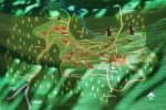
Notes about the Google Earth screenshot: the graph at the bottom shows elevation of the track (pink area) and speed (the blue line).
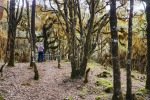
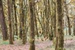
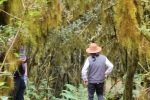
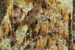
 The forest throughout this area is lush with a tremendous diversity of plant life – trees, “shrub” plants, fungi, bromeliads, mosses, lichens, things that I wouldn’t recognize. Upon reaching near 10,000 feet elevation the forest changed. The tree trunks were covered with moss and strands of moss hung from every branch – this is clearly a different kind of forest.
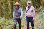
The trail is wide and covered with a thick layer of leaves, needles, etc., much like a thick carpet – easy walking. And it is generally flat, tho’ does descend some distance from the parking area. So this is not so much a hike as a walk through an amazing forest, with the unusual drab green colors, the mosses and lichens on the tree trunks, and moss draped on nearly every non-vertical branch. At the end the first leg of the walk we climbed up on a 30′ tall tower, enjoying a great view across the mountain tops, over clouds above and below in the valleys, and into other valleys. We walked as far down the second leg as permitted, not far enough to reach Los Pozuelo, the pool of water mentioned in the description below.
 I
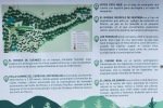
I n addition to the rainforest itself, the information on the signs tell a larger story. The story here in Ixtlán del Juárez is consistent with the overall attitude of this villate and the others in the Pueblos Moncomanados – honoring and preserving their history and the natural environment. Rather than leave you to read the Spanish, I offer the translation below.
Cerro de los Pozuelos (Mountain of the Wells)
THE SIERRA JUÁREZ DE OAXACA is considered by CONABIO as a priority region for the conservation (RTP 130), as it is a region important for its great biodiversity, directly related to their particular physiography and a mixture of ecological variables.
The region is part of the Area of Importance for the Conservation of Birds number 11 (AICA 11), since In its forests inhabit 66 endemic species or quasi-endemic, such as the Dwarf Chara (Cyanolica nana).
This zone is separate from the areas of high value of conservation (AVC), recognized by. the community and certified by the Forest Stewardship Council (FSC) which together form an approximate surface of 7,595 hectares, between tropical forests and mountain mesophiles, in the latter are concentrated species of flora and fauna in danger of extinction, recognized in national and international standards.
VISITOR’s CODE
1.- Follow all the instructions that the Guide tells you for the use of the area.
2.- Respect all trails, avoiding leaving it.
3.- Respect the area. (Do not cut, mutilate, or extract specimens of plants, animals, fungi or rocks).
4.- Make campfires only in the areas intended for this purpose.
5.- Transport all waste with you generated during your visit, both organic as inorganic.
Remember that this forest is the cultural and natural heritage of the inhabitants of the community of Ixtlán de Juárez, for that reason respect all living beings They inhabit our forests.
You are here, in the camping area that has space for a campfire and a place of shelter.
THE MOUNTAIN MESOPHYLL FOREST is the type of vegetation that is endangered in Mexico, as it has been reduced to a small percentage, in it that we find vegetation relic, existing since the time of the dinosaurs.
-
-
- LOS POZUELOS is located 600 m from this Point, this place is much appreciated, as here. The water that filters from the top of the hill is born and when travelers used the Camino Real, They rested and drank water, before continuing their journey to the community of Ixtlan.
- EL CAMINO REAL is a pre-Hispanic road transited by the Zapotecs, which communicated to the villages of Rincón and Chinantla with the Valleys Central. With the arrival of the Spaniards, it was extended to the state of Veracruz.
- THE THOUSAND-YEAR-OLD TREE is an oak (Ouercus sp.), in the center of the clearing, adorned in a way natural at its base, trunk and branches by epiphyte plants (plants that live on other plants), mosses, lichens and ferns, attributes that give it a high scenic beauty.
- THE FOREST OF GOBLINS is a humid temperate forest, whose main vegetation are the dwarf pines (Pinus sp.). that do not reach the 30 meters high, developing at more than 3,000 meters above sea level.
- AT THE TOP OF CERRO DE LOS POZUELOS you will find a tower of observation at 3,150 meters above sea level, where you can contemplate the formation of medium clouds, effect caused by moisture convergence coming from the Gulf of Mexico and the Pacific Ocean, you can also observe the Cerro del Zempoalteptl, the peak of Orizaba and the coastal plain of the Gulf of Mexico.
-
The Drive Out
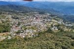
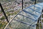
 After the hike, we drove back down the road and turned toward the Mirador de Cristal, an attraction created by Ixtlan de Juarez to offer an impressive view of their village and the surrounding valleys, mountains, and some of the other villages. The Mirador is a steel structure that extends from the sharp end of a ridge above the village of Ixtlán del Juárez. In addition of the superb view of the village and the valleys beyond, the floor of the platform is glass, a challenge for those uneasy about being high with an open supporting structure. We did make a couple of rounds to test our mettle.
The truck from Ecotourixtlan that took us to the Rainforest and then to Mirador de Cristal having left, we rode back to the village in one of the ever-present moto-taxis.
Highlight
Most impressive was the transition to the nearly all green forest common above 7,000 feet in the Sierra Norte into this Rainforest. It gave me an eerie feeling, the colors and draped moss that changed the whole feeling of the forest.
Statistics
Total Distance: 1.6 miles, 2.57 m
Elevation: start 10,059 ft, maximum 10,200 ft, minimum 10,018 ft
start 3,066 m, maximum 3,109 m, minimum 3,053 m
Gross gain: 213 ft. Aggregate ascending 213 ft, descending 307 ft
gain: 65 m Aggregate ascending 65 m, descending 94 m
Maximum slope: 28% ascending, 32% descending, 8.8% average
Duration: 1:45
| GPS Track Files for Download | |
137 Downloads |
|
|---|---|
101 Downloads |
|
114 Downloads |
|
132 Downloads |
|
If you haven’t explored these hiking tracks with Google Earth, I urge you to try it. With the virtual 3-dimensional presentation, achieved by panning and tilting the view, you can get a much better idea of the hikes and terrain than you can get from the screenshot above. For some ideas, check out Using Google Earth Track Files.
Related Posts
Other hikes to Capulálpam
Other hikes around Oaxaca.
References and Resources
Oaxaca Mio: Ixtlán de Juárez
Motociclo: Destinos para Llegar Rodando, Ixtlán de Juárez
ViveOaxaca: Ixtlán de Juárez, Oaxaca (Información y Ecoturismo)
AllTrails: Cerro de los Pozuelos
El Universal Oaxaca: Mirador de cristal de Ixtlá de Juárez, Oaxaca …
Escapada: Mirador de Cristal de Ixtlán, la belleza arquitectónica que atrapó a Yalitza Aparicio
Food and Pleasure: Conoce el mirador de Cristal … 100 metros más alto …
And many more via GoogleSearch


