
Jay and I returned to a trail we have enjoyed in the past (see Related Posts below).
The Drive In
Access to the trailheads for both trails is via the Forest Loop Rd off of NM 165 east of the Placitas Cafe. There are two entrances, not far from each other: from the Placitas Cafe the first one – .5 miles, the second one – .8 miles; the second one is preferred. The Loop Road is quite rough with rocks exposed throughout; a high-clearance vehicle isn’t required but the suspension of any vehicle will get a workout. There are two parking places, one for the Piedra Lisa trailhead (1.9 miles from NM 165), the other for Del Agua (2.0 miles from NM 165).
The Hike
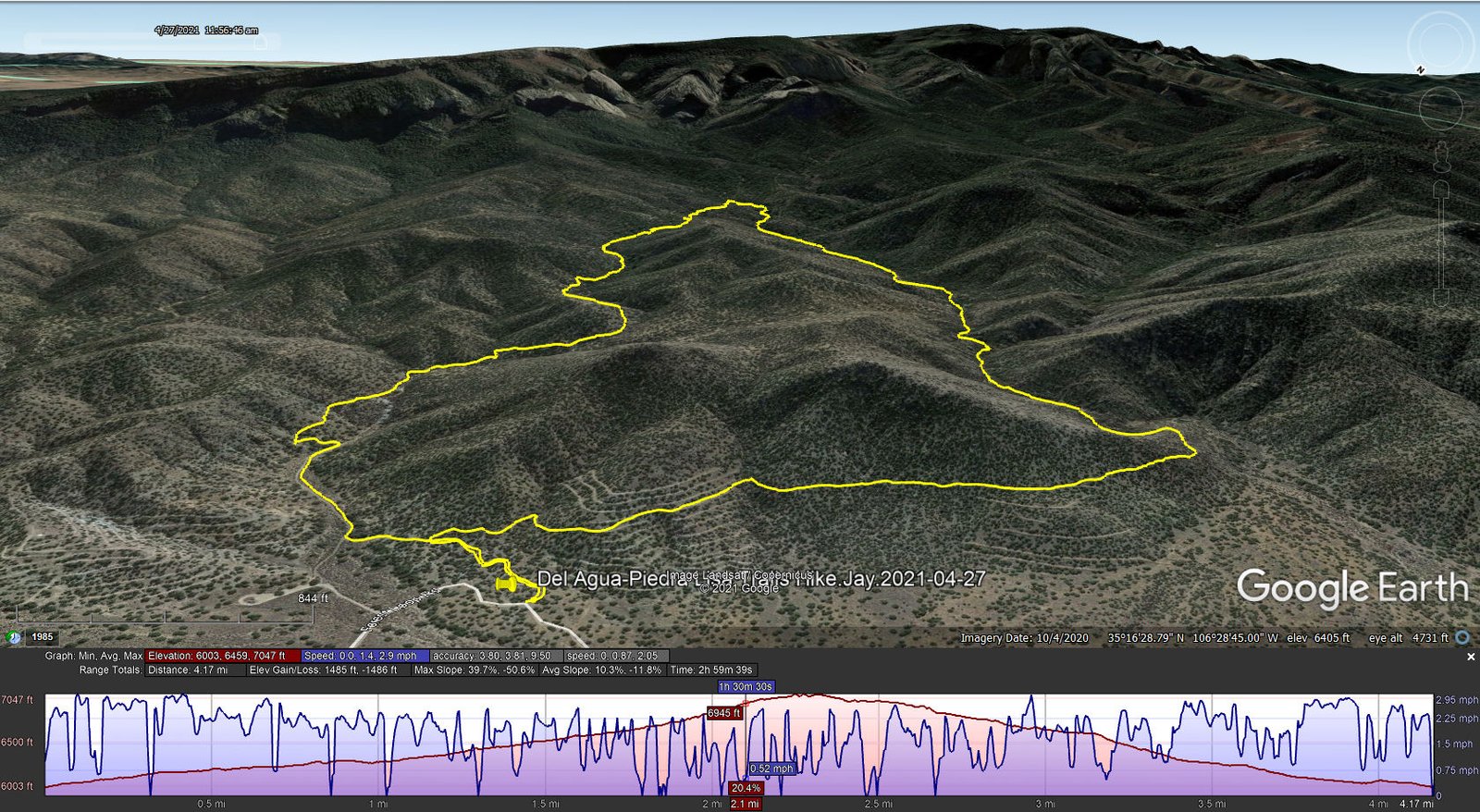
Del Agua-Piedra Lisa Trails Hike.Jay.2021-04-27
We enjoyed our revisit to this loop and these two trails. The description for our hike back in 2019 covers it quite well.
Highlight
On the way down Piedra Lisa, not far from the intersection with Agua Sarca, we spotted an outcropping of white rock. It appeared to be similar to the “Quartz Outcrop” that we’ve hiked to a couple of times. If so, then we were unexpectedly close to that hike. But checking the topo map, and reviewing the tracks for the Quartz Outcrop hike, we concluded that it is another such Outcrop. And it becomes another destination, to cross the intervening arroyo from Piedra Lisa to inspect it more closely.
Jay Here: Just want to add that one of the terrific things about this hike was that on the entire way up and the way back, we did not encounter a single other hiker/biker. One of the advantages of being retired and hiking on a weekday!
Statistics
Total Distance: 4.17 miles
Elevation: start 6,005 ft, maximum 7,047 ft, minimum 6003 ft
Gross gain: 1044 ft. Aggregate ascending 1,485 ft, descending 1,486 ft
Maximum slope: 40% ascending, 51% descending, 11.0% average
Duration: 3:00
| GPS Track Files for Download | |
292 Downloads | |
|---|---|
177 Downloads | |
If you haven’t explored these hiking tracks with Google Earth, I urge you to try it. With the virtual 3-dimensional presentation, achieved by panning and tilting the view, you can get a much better idea of the hikes and terrain than you can get from the screenshot above. For some ideas, check out Using Google Earth Track Files.
Related Posts
Del Agua-Piedra Lisa Trails Hike – 11/17/2019
Del Agua-Piedra Lisa North Hike – 04/24/2016
Del Agua-LPiedra Lisa North Hike – 03/09/2013
Del Agua Hike – 03/22/2015
NoName-Quartz Outcrop Hike – 09/23/2018
References and Resources
USFS: Del Agua Trail #248
Piedra Lisa North Trailhead-Piedra Lisa Trail 135
AllTrails: Piedra Lisa Trail and Del Agua Trail Loop
GAIA GPS: Del Agua Trail and Piedra Lisa Trail Loop
Dog of the Desert: A note on Del Agua Trail in the northern Sandias
ondafringe: North Piedra Lisa/Del Agua Loop
Hiking Project: Piedra Lisa Trail #135


