On this day, we set out to explore FR 144 beyond our previous furthest hike, Pony Canyon. Specifically, we chose a route down into San Antonio Canyon, following a two-track depicted on the Topo maps. We didn’t know what to expect – GoogleEarth didn’t show much of a track down the 700 feet from FR 144 to the Canyon floor. But, it is a two-track that has been used in recent times, making for an easy descent.
The Hike
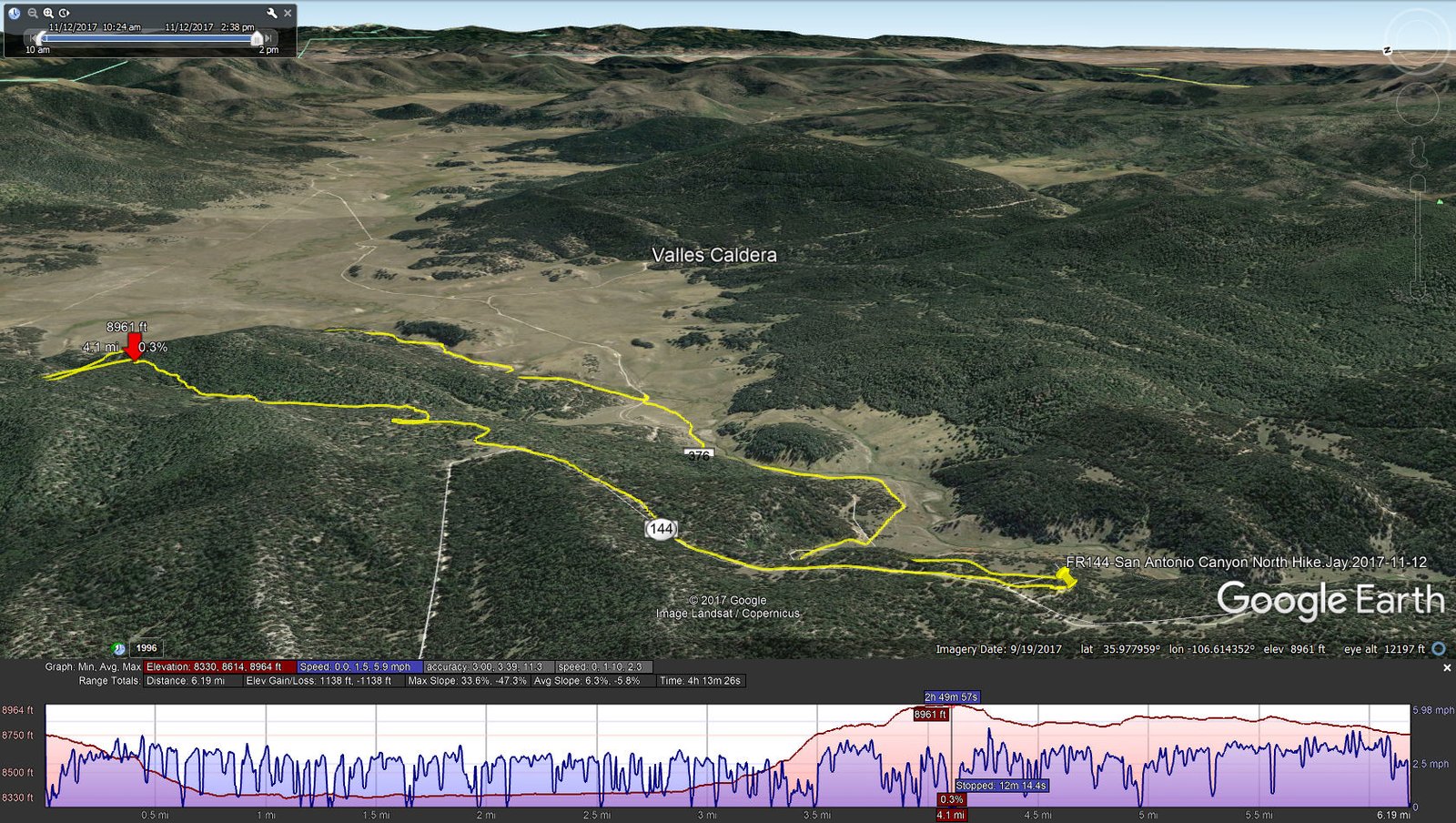
San Antonio Canyon North Hike.Jay.2017-11-12
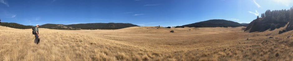
As we hiked down the two-track, we enjoyed the views of the open valley and the Rio San Antonio. We proceeded southeast along this bend in the Rio, then rounded up northeast to follow the Rio upstream. The view across the Caldera were stunning – rolling hills covered with grass and the rim mountains on the horizon.
Following a sketched track that I had made with Google Earth, a times on a two-track and sometimes following a fence, we hiked along the Rio for a while, enjoying the sound of a steady stream of water over rocks. Where the Rio turned northeast towards the middle of the Caldera, we headed north towards a two-track that appeared on Google Earth to provide a reasonable ascent back atop the ridge. Along the way we passed three active springs, the first one feeding directly into the Rio.
As we proceeded along the edge of the open Caldera, to the left were steep slopes, sometimes cliffs, up to the top of the ridge. After crossing two or three ridges, we came to the “canyon” that seemed to offer the best chance for an “easier” ascent. After some bushwacking, we discovered an old two-track, consistent with our suspicions – those two-track makers would certainly find the best routes. It was still a challenging climb – some 500 feet in less than a mile. Once on top we stopped for our mid-hike break among a beautiful of now leaf-less aspen, their white trunks reaching up for New Mexico’s blue skies.
We continued on the two-track that brought us up on the ridge. From here we made good time on two-tracks, some with signs of recent traffic.l After a couple of intersections with other two-tracks and a brief bush-whack along a fence, we were back at the truck. This was another amazing hike.
Jay here: It was a sight stopper. The bubbling creek running through the Caldera was a bonus attraction. I never catch a break on the bushwhacking…not sure why that is. Wait, I know why. George has the maps!
Statistics
Total Distance: 6.19 miles
Elevation: start 8,761 ft, maximum 8,963 ft, minimum 8,334 ft
Gross gain: 629 ft. Aggregate ascending 1,212 ft, descending 1,214 ft
Maximum slope: 34% ascending, 45% descending, 7% average
Duration: 4:13
| GPS Track Files for Download | |
229 Downloads | |
|---|---|
190 Downloads | |
281 Downloads | |
179 Downloads | |
If you haven’t explored these hiking tracks with Google Earth, I urge you to try it. With the virtual 3-dimensional presentation, achieved by panning and tilting the view, you can get a much better idea of the hikes and terrain than you can get from the screenshot above. For some ideas, check out Using Google Earth Track Files.


")

")


