This was our 2nd day of 3 days camping and hiking around Valles Caldera in the Jemez Mountains. ‘Tho we would like to have headed deep into the Caldera, the washed out road just 5 miles in held us at bay. So .. we checked the Valdes Caldera and Bandelier brochures and came up with the Alamo Springs Trail, depicted on the Bandelier map.
The Drive In
With some trepidation about road conditions, from NM 4 we headed south on Forest Road (FR) 289 (St. Peter’s Dome Road), passing the southern trailhead for Bandelier’s Alamo Boundary Trail. At 2.25 miles on FR 289, we turned left on FR 287 (Sawyer Mesa Rd). As expected we encountered a gate (.5 mi) which blocked further travel by auto; here there was ample parking and sufficient room to turn around.
The Hike

Alamo Spring Hike.Pat.2019-05-28
Passing around the heavily fortified gate, we continued south on the Alamo Springs Trail (formerly Sawyer Mesa Rd, now a two-track). From the topo maps we could see that we would soon be hiking along the edge looking down into Alamo Canyon to our right. A mile and three quarters further on, Frijoles Canyon would converge from the left forming a narrow passage on the mesa top as we hiked towards Mesa del Rito. (Note: At the far end of Mesa del Rito the Alamo Springs Trail enters Bandelier National Monument where it becomes the Frijoles Rim Trail.)
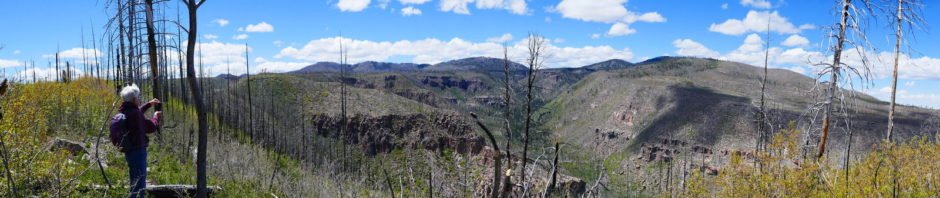
This trail passes through a part of the forest burned in the devastating Las Conchas fire back in June of 2011. The fire took out -most- of the ponderosa and fir trees, leaving open room for amazing views along the mesa, into the canyons, and beyond to the mountains in the distance. There are, of course, many fallen trees, some having come down only recently. Now some 8 years later Mother Nature is showing her reclamation of the area – many groves of young aspen, pockets of scrub oak, and other bushes (some with nasty thorns) dot the landscape. Grasses cover nearly all of the ground – many kinds, tall and short, many with their seed heads in full glory. To punctuate the scene, I counted some 17 different flowering plants, lending a sparkle of color to the surroundings.
The views are stupendous, so amazing that they created tension which we think explains (or we use as an excuse) why were became quite weary (‘tho only 5.6 miles in length and with very little change in elevation). The trail follows a two-track, smooth mostly sandy surface, occasionally requiring we climb over a fallen tree. We did occasionally take excursions over to the edge of the mesa for a closer view of the canyons. As we entered the narrow section mentioned above, we began seeing shards of obsidian. Soon the ground was peppered with pieces ranging from <1″ to 2, 3, even 4 inches in size. Later we noticed that this section between mesas is named Obisidian Ridge (duh).
The afternoon was wearing on, so to leave time to return to the truck and the camper, we stopped for our mid-hike break/lunch, then headed back to the truck and the R-Pod at Jemez Falls Campground. Reflecting back on our experience, we realize that it is difficult to convey the beauty of the scenery with words or photos (‘tho we try); one really must be there to appreciate it fully. We will go back to enjoy this trail again.
Statistics
Total Distance: 5.64 miles
Elevation: start 8,755 ft, maximum 8,818 ft, minimum 8,379 ft
Gross gain: 438 ft. Aggregate ascending 749 ft, descending 751 ft
Maximum slope: 18% ascending, 23% descending, 4.2% average
Duration: 5:08
| GPS Track Files for Download | |
226 Downloads | |
|---|---|
242 Downloads | |
230 Downloads | |
384 Downloads | |
I urge you to explore our hiking tracks with Google Earth. With the virtual 3-dimensional presentation, achieved by panning and tilting the view, you can get a much better idea of the hikes and terrain than you can get from the 2-dimensional screenshot above. For assistance: Using Google Earth Track Files.
References
USDA Forest Service: Alamo Spring Trail #114
National Park Service:
Bandelier Park Map (Interactive and PDF download)
Alamo Boundary Trail


