Two weeks ago we hiked up the Gooseberry Springs Trail on Mount Taylor near Grants. That was such a great hike, we decided to return soon with the goal of going all the way to the top. So that we could make an early-morning start, we traveled to Grants the day before and spent the night in a motel. (On the lookout for craft beer, we stumbled on the Route 66 Junk Yard Brewery – check it out on the east end of town.)
The Drive In
See the description in the previous post Gooseberry Springs Trail Hike – 06/01/2018
The Hike
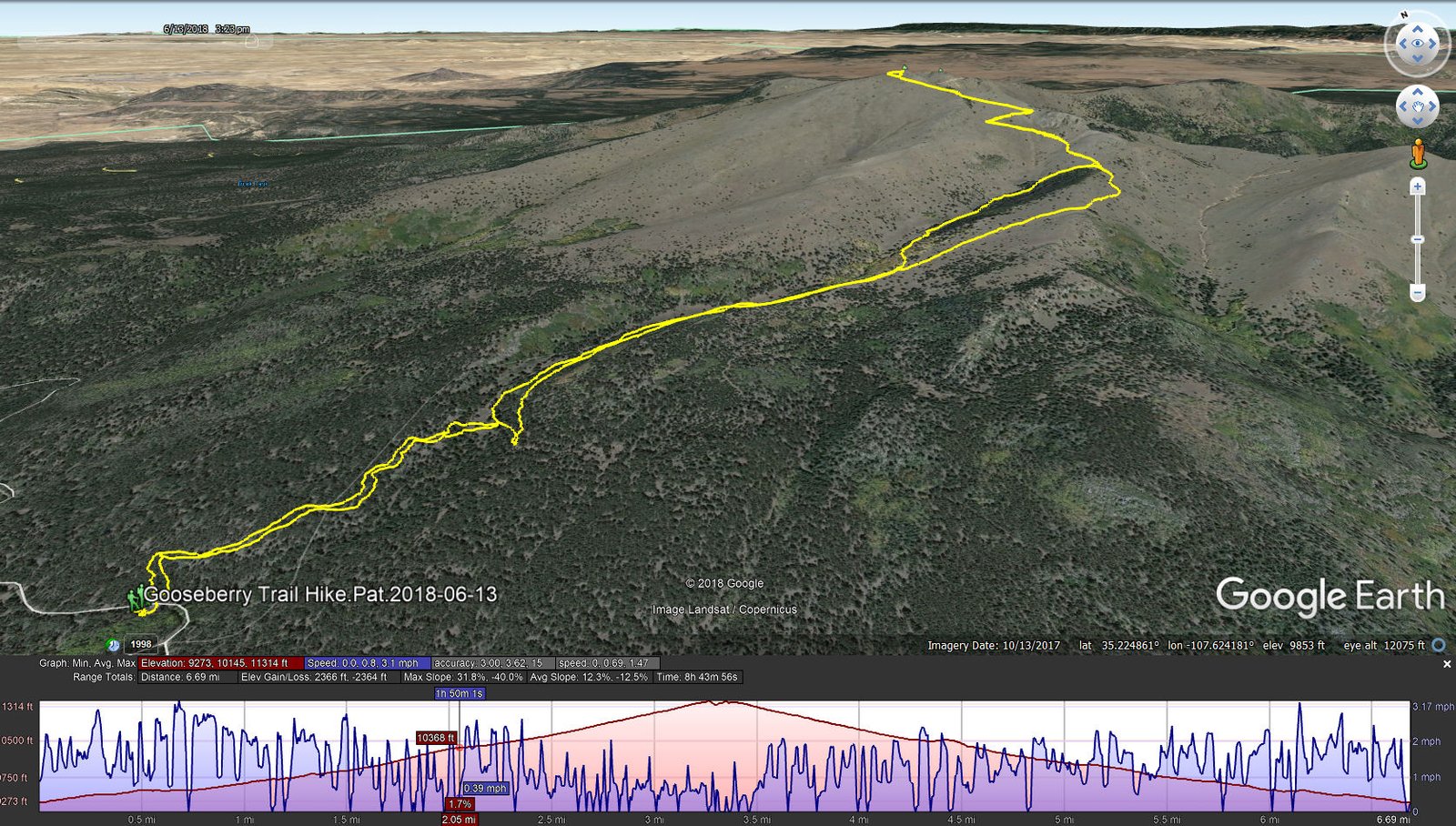
Gooseberry Trail Hike.Pat.2018-06-13
After a McDonalds burrito and coffee breakfast (the only restaurant in Grants that is open early), we headed for the Goosberry Trail trailhead. See the report on our earlier hike for particulars on the first half of this hike. Oh, by the way, we made the turn onto the Trail that we missed on the previous hike. And knowing we faced a 2,000+ elevation gain, we took frequent breaks (and kept up the intake of water).
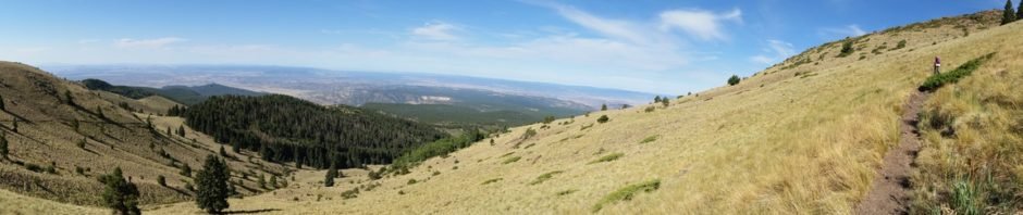
Nearing the location of our mid-hike break on the previous hike, above the tree line on this side of the mountain, we headed up towards the summit. The trail continued to be a moderate slope, well used and easy going, ‘tho on fairly steep hillsides. The views to the east, south, and west were glorious, despite the hazy atmosphere. And the views of the surrounding slopes of the mountain were stunning, particularly in the light of the early morning sun. An occasional rock outcrop added another dimension of Mother Nature’s beautiful work. ‘Tho it has been hot at lower elevations, the early start coupled with the upslope breezes made the weather conditions quite cool and pleasant.
Reaching the summit, we enjoyed an extended break with coffee and empenadas, and taking time to enjoy the sights. Heading down, again the slope and general condition of the trail made the descent reasonably easy. And looking at the scenery from this new angle or direction made it beautiful in ways different that during the ascent.
Close to a mile from the summit on the way down, we opted to follow the ‘canyon’ towards -the- Gooseberry Spring. ‘Tho not a marked trail, we found ‘trails’, tracks left by cattle, elk or deer, a maybe people, that were easy to follow and allowed us to remain in shade (the temperature was rising and the sun intense). For a short time we rejoined -the- Gooseberry Trail, but then descended again into the ‘canyon’ and followed it until the point where the Trail crosses the ‘canyon’. From there it was about 2/3rd of a mile back to the truck.
Statistics
Total Distance: 6.69 miles
Elevation: start 9,273 ft, maximum 11,314 ft, minimum 9,273 ft
Gross gain: 2,041 ft. Aggregate ascending 2,366 ft, descending 2,364 ft
Maximum slope: 32% ascending, 40% descending, 12% average
Duration: 8:44
| GPS Track Files for Download | |
279 Downloads | |
|---|---|
200 Downloads | |
If you haven’t explored these hiking tracks with Google Earth, I urge you to try it. With the virtual 3-dimensional presentation, achieved by panning and tilting the view, you can get a much better idea of the hikes and terrain than you can get from the screenshot above. For some ideas, check out Using Google Earth Track Files.
References and Resources
See Gooseberry Springs Trail Hike – 06/01/2018


