Our second day on a camping trip to the Grants area instead of heading to the Jemez (see the post for the Bluewater Lake Hike). We had considered the Coal Mine Campground for the previous night, but because this was our first trip out with the R-Pod, we took the easy route – Grants KOA. On this day, ‘tho, we set out to check out the Coal Mine Campground and after a visit to the Mount Taylor Ranger Station, hike the Gooseberry Springs Trail.
The Drive In
The campground is quite nice, with a few nicely shaded sites (no electric services, but the usual pit toilet in National Forest campgrounds). Having checked out of the KOA, we brought the R-Pod up the 9 miles and 1,000 feet elevation gain (on a very nice paved road) to Coal Mine Campground and parked it in a nice drive-through site. After brunch, we headed on up Lobo Canyon Road/NM 547 to the turnoff (FR 193, gravel) to the trailhead (5.2 miles) for the Gooseberry Springs Trail. FR 193 passes through ponderosa and juniper forest, but with many turnoffs that appeared to be quite suitable for primitive camping (RV or tent).
The Hike
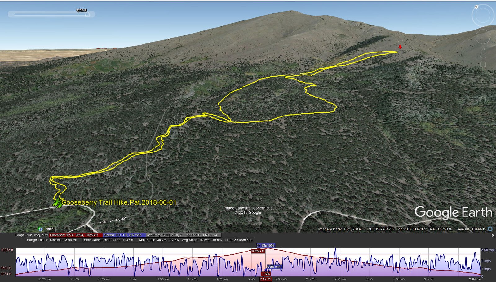
Gooseberry Springs Trail Hike.Pat.2018-06-01
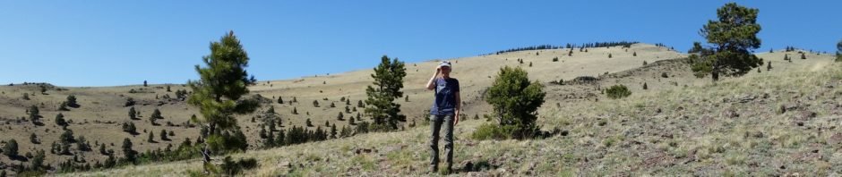
The trailhead is clearly marked, as is the beginning of the trail. However … at about 3/4 miles into the hike we missed a turn for the -real- trail and followed an old two-track that was quite rocky in spots. After about 1.5 miles, with the help of a trail track on US Topo on the phone/GPS, we headed up-hill (easy bushwhacking) and across where we found a well-used, easy to walk trail. We followed this uphill for another .25 miles when we found ourselves out of the forest, on more open land.
As we continued uphill, there were fewer trees until we came into completely open space with stupendous views to the south and west. Another .25 miles and we were at the top of a saddle and could now see the vista to the east. After enjoying our mid-hike coffee/snack break, we headed back downhill, passing many cows and calves which we had encountered on our way up. We stayed on that well-used trail for the distance back to the truck.
Throughout the hike, especially on the actual Gooseberry Springs Trail, the climb and descent, the slope was gentle. The trail surface was rocky in very few places; otherwise dirt or, in the forested area, covered with pine needles. It is another mile or so from our mid-hike break spot to the top of Mount Taylor. That portion of the trail is completely in the open, great for the vista views. We could see the trail as it tracked up the slope with one large switchback about 2/3rds to the top. We’ll be going back soon to make it to the top.
Statistics
Total Distance: 3.94 miles
Elevation: start 9,274 ft, maximum 10,253 ft, minimum 9,274 ft
Gross gain: 979 ft. Aggregate ascending 1,147 ft, descending 1,147 ft Maximum slope: 38% ascending, 28% descending, 11% average
Duration: 3:46
| GPS Track Files for Download | |
238 Downloads | |
|---|---|
309 Downloads | |
287 Downloads | |
181 Downloads | |
If you haven’t explored these hiking tracks with Google Earth, I urge you to try it. With the virtual 3-dimensional presentation, achieved by panning and tilting the view, you can get a much better idea of the hikes and terrain than you can get from the screenshot above. For some ideas, check out Using Google Earth Track Files.
References and Resources
US Forest Service: Gooseberry Springs Trail
Gooseberry Springs Trailhead
Four Corners Tourism: Gooseberry Springs Trail – Mt. Taylor
AllTrails: Gooseberry Springs Trail to Mount Taylor
SummitPost: Mount Taylor
Gooseberry Springs Trail
Hiking Project: Gooseberry Trail
ondafring: Day Hike: Mount Taylor
ASCHG: Mount Taylor From Gooseberry Spring Hike
Stav is Lost: Hike Mt. Taylor via Gooseberry Springs Trail


