Introduction
Pat and I went looking for new places. We have visited Paliza Canyon many times, visiting Goblin Colony and Boletsakwa & Kiatsukwa Ruins. We have been curious about a forest road, FR 266, that heads east off of FR 10 .4 miles above the Paliza Campground; we checked out on this day. As interesting as the hike was the drive to the trailhead.
The Drive In
Directions to Paliza: US 550 to San Ysidro, north on NM 4 to the turn to the right onto NM 29o. Continue through the settlement of Ponderosa, then about 3 miles to the boundary of the Cibola National Forest, then another 1.5 miles to the Campground. Turn left across a one-lane bridge, then 500 yards to the intersection of FR 10, 266, and 271 (FR 271 proceeds up Paliza Canyon itself). A sign at this intersection advises that one can proceed only a few miles; one cannot continue through to Tent Rocks. FR 266 proceeds past the Christian Life Center and heads uphill, rounding the bitter end of Peralta Ridge.
For about .5 miles the road is narrow and on a very steep hillside, nearly straight up on the left, nearly straight down on the right. The roadbed itself is in good condition, at least typical for these mountain roads – we passed another intrepid soul who had come up the road in a small sedan. Atop the ridge, the road is “nice” – dirt, little elevation change, easy driving. ‘Tho we did not stop to investigate, I’m fairly certain that we passed a rather large Pueblo ruins a mile or so from reaching the ridgetop (gleaned from USGS Topo from 1915). We started our hike about 4 miles further on, where FR 266 makes a very hard turn to the right, south and downhill, into Guacamalla Canyon.
The Hike
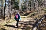
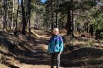
The trail generally follows an easy two-track with a steady climb (500 feet for the first .7 mile, then levels out somewhat. It then becomes a bit steeper, climbing 200 feet in the last .1 mile. On the way we encountered the only person this hike, a gentlemen on the most quiet off-road bike. He pointed out the fire lookout on Cerro Pelado north of us, suggesting that as another destination in the future (and that he had seen one elk that day – we’re still on the lookout for one).
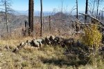
After 1.2 miles, where Peralta Ridge turns to the north, we found ourselves on the brink of a steep descent into Peralta Canyon; maps show that this trail descends to meet up with the Peralta Canyon Trail #140. We could not find any evidence of such and the descent appeared quite daunting. We climbed to the highest point nearby on the ridge for our mid-hike break, and enjoyed beautiful view down into Peralta Canyon, across to Bearhead Ridge and Aspen & Ruiz Peaks. On the nearby slopes we saw evidence of fire (featured photo above); I’ve not been able to identify the guilty fire to learn how long ago it burned here.
Statistics
Total Distance: 3.36 miles
Elevation: start 8,618 ft, maximum 9,145 ft, minimum 8,618 ft
Gross gain: 527 ft. Aggregate ascending 927 ft, descending 969 ft
Maximum slope: 39% ascending, 38% descending, 11% average
Duration: 3:15
| GPS Track Files for Download | |
178 Downloads |
|
|---|---|
116 Downloads |
|
146 Downloads |
|
169 Downloads |
|
I urge you to explore our hiking tracks with Google Earth. With the virtual 3-dimensional presentation, achieved by panning and tilting the view, you can get a much better idea of the hikes and terrain than you can get from the 2-dimensional screenshot above. For assistance: Using Google Earth Track Files.
References
US Forest Service: Peralta Ridge Trail #126


