We have enjoyed very much hiking in and around Valles Caldera this year. With more research, and in particular Coco Rae’s recently published book, “Hiking Trails in Valles Caldera National Preserve”,we are finding places “off the beaten path”. For our first hike during this 3-night camping trip (R-Pod to Jemez Falls Campground), we were intrigued by the description of “.. otherworldly sulfur fields to pretty creek-lined meadows ..” in the Sulphur and Alamo Canyons.
The Drive In
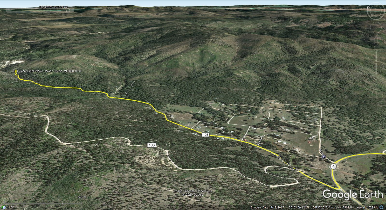
Sulphur Creek-Alamo Canyon Drivein.Pat.2020-10-13
The drive to the trailhead, also the western boundary of the Valles Caldera Preserve, turn north off of NM 4 at milepost 27, onto Sulphur Creek Road. The trailhead is about 2.25 miles from the turn off of NM 4 on a decent Class 3-4 road. (A sign at the turnoff points the way to Forest Road 105.) Some 200 yards from NM 4, at a ‘Y’ in the road, take the leg to the right; another sign points you along to FR 105. (For the first 3+ miles the road passes through an area of private property – Sulphur Creek Road. Once entering Forest Service property the road becomes FR 105.) A gate closes the road where it enters into the Valles Caldera National Preserve. There is sufficient parking alongside the road for up to a half dozen cars.
The Hike
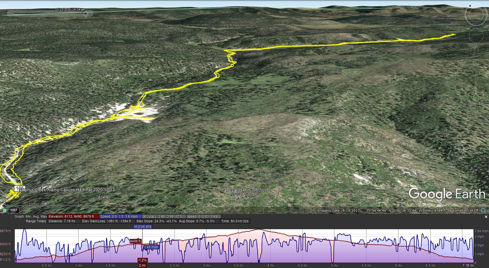
Sulphur Creek-Alamo Canyon Hike.Pat.2020-10-13
This hike is on a two-track for its full length. Through Sulphur Canyon it presents a steady moderate ascent. The surface is gravel and rock typical of a two-track in active use – it has seen heavy use recently as a crew has been thinning the forest along the road. After turning into Alamo Canyon the road is less used, in some places covered over with grass.
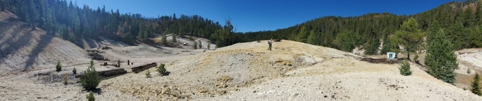
A place of interest to us was an area a half a mile into the hike: an area with “.. geothermal features like mud-pots and fumaroles ..”. It was a sulfur mine early in the 20th century, then a health spa through 1970, and in the 1980s a site experimenting with geothermal wells for energy production.
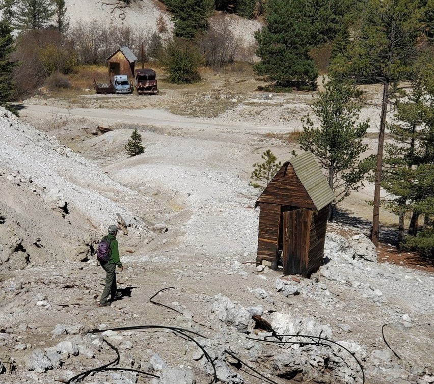
Bath house and Office for Sulphur Canyon Spa.
We knew we were approaching the area because of the smell of hydrogen sulfide. We explored the area with its numerous mud-pots and fumaroles, intrigued by the bubbling “froth” in a half dozen small mud-pots. And scattered around the area were relics from those past activities.
Our hike continued up the two-track following Sulphur Creek; we flushed a turkey from deep grass a half mile on. This part of the hike was very pleasant until, that is, we neared the turn into Alamo Canyon – the noise from the chain saws of thinning crews disturbed the quiet of the wilderness.
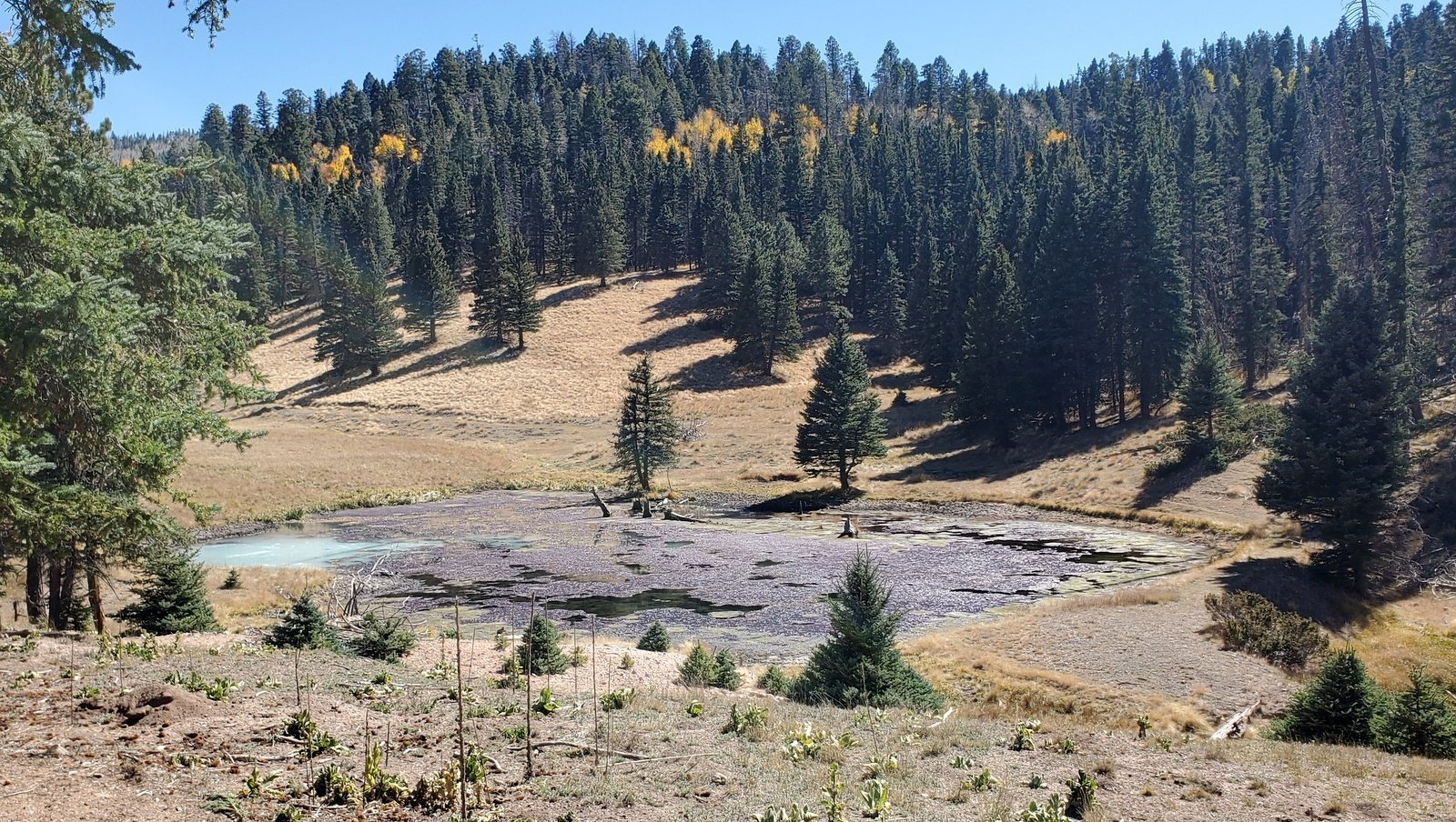 Turning right into Alamo Canyon, we passed another area of geothermal activity. It opened up into a wide valley for the first mile with great view of Redondo Border to the southeast. About half a mile on we came to the first of 3 ponds in the canyon. These are quite interesting with geothermal activity in one corner of the ponds. Most of the water in the pond was crystal clear
 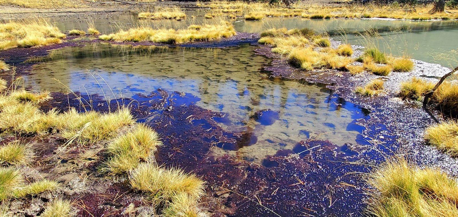 revealing a shallow muddy bottom. Large areas of the ponds were covered with a purple “scum”, a plant we suppose that thrives on the sulfur content of water from the geothermal activity. In one corner or along one edge of each pond the water was a milky white with bubbling gas scattered about.
And such was the situation for each of the 3 ponds. This was such a pleasant hike that we discovered we had gone beyond our usual distance without realizing it. We found some shade, enjoyed our lunch, and returned to the Tacoma continuing to enjoy the autumn colors.
Statistics
Total Distance: 7.18 miles
Elevation: start 8,143 ft, maximum 8,879 ft, 8,112 minimum ft
Gross 767 gain: ft. Aggregate ascending 1,381 ft, descending 1,394 ft
Maximum slope: 24% ascending, 43% descending, 5.5% average
Duration: 5:32
| GPS Track Files for Download | |
183 Downloads | |
|---|---|
268 Downloads | |
194 Downloads | |
240 Downloads | |
I urge you to explore our hiking tracks with Google Earth. With the virtual 3-dimensional presentation, achieved by panning and tilting the view, you can get a much better idea of the hikes and terrain than you can get from the 2-dimensional screenshot above. For assistance: Using Google Earth Track Files.
References and Resources
National Park Service: Valles Caldera National Preserve Acquires Property with Unique Volcanic Features
Hiking Trails in Valles Caldera National Preserve, Coco Rae,a
Dog of the Desert: Sulphur and Alamo Canyons in the Valles Caldera
Prime Passages: A Hike in Alamo Canyon (**excellent info on Valles Caldera and hiking there)
Natural Atlas: Sulphur Creek
OpenEI: Valles Caldera – Sulphur Springs Geothermal Area
The Great Desert: Geolgy …: Sulphur Springs
YouTube: Sulphur and Alamo Canyons in the Valles Caldera (video)


