
Introduction
Having attended the Open House and Fly-In at the Los Alamos airport (KLAM), I took advantage of continuing west on NM 4 for a bit of a walkabout near Valles Caldera. We’ve hiked to the top of Cerro Grande, so I was familiar with the first half mile – an easy trail as I work towards getting back in hiking shape after nearly a year of “limited duty”.
The Drive In
To get there, from either direction on NM 4:
East 5 miles from the entrance to Valles Caldera
West 5 miles from the intersection of NM 4 and NM 501 (the road through Los Alamos)
Parking is on the north side of NM 4.
The walkabout
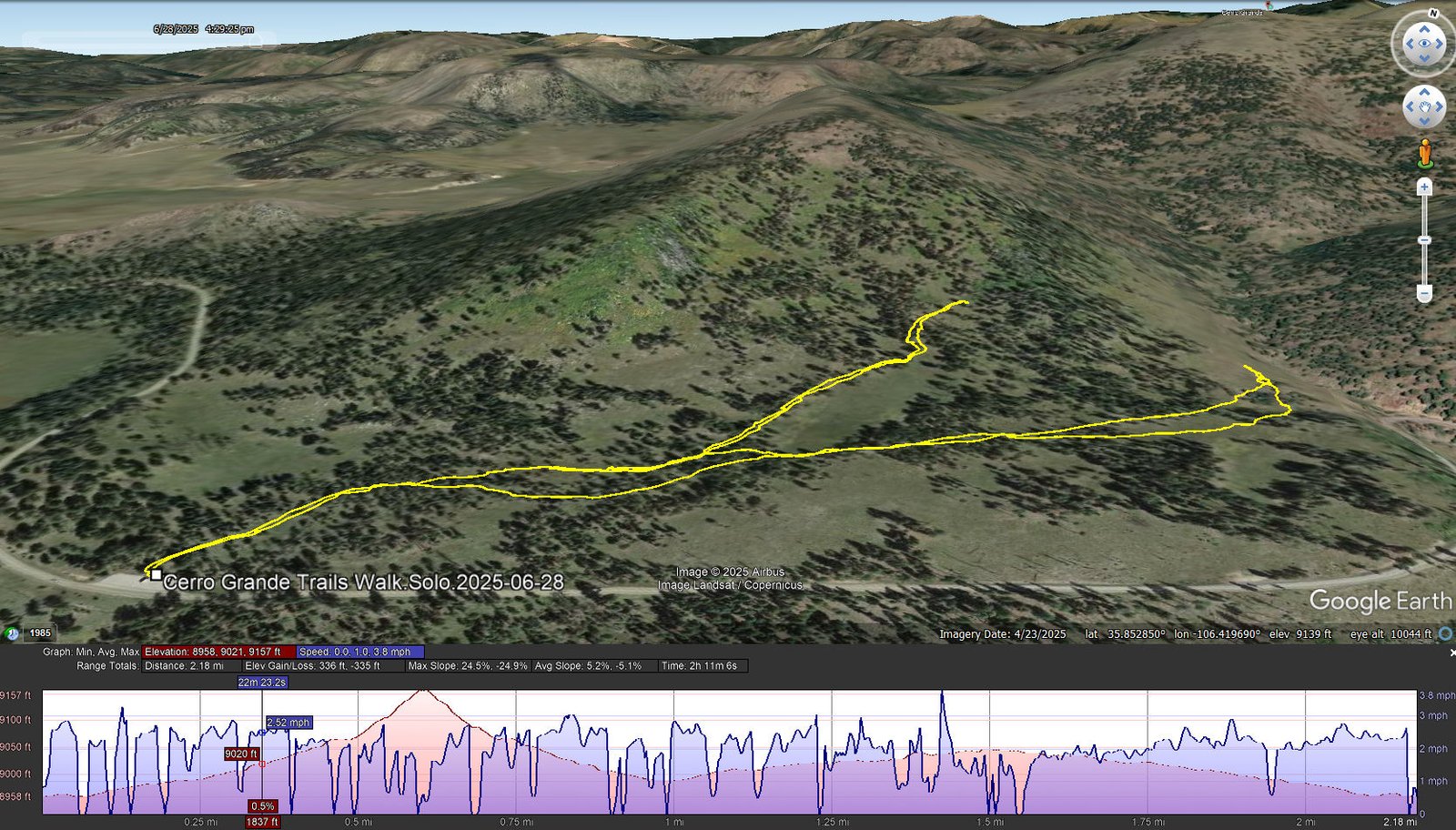
Cerro Grande Trails Walk.Solo.2025-06-28
Notes about the Google Earth screenshot: the graph at the bottom shows elevation of the track (pink area) and speed (the blue line).
The plan was to hike as far as the slope of the trail remained gradual, knowing from experience (and checking past hikes), that at a point it would take a significant turn -up-. And I was not ready for any significant climbing. So … at half a mile, encountering an abrupt change in slow, and then a rocky surface, I turned around.
One of the great enjoyments of hiking in these mountains during the summer – flowers. I counted 14 different flowering plants during this ~mile walk; pictures of a few are above.
Wanting more, and being curious, I chose to explore a “trail” that is marked on GAIA (and on other maps). A few hundred yards from the trailhead approcimately where the map indicated, I found no sign of any trail. Curious enough, I proceeded to follow the track as it went northeast towards a canyon that goes up to a crest just north of Cerro Grande. The terrain is easy – generally flat, a few areas of small rocks, covered in tufts of calf-high grass. I continued on to the entrance to the small canyon where I found the first sign of a “trail” – evidence typical of an access road put in place decades ago. It might be worth exploring further some day.
Statistics
Total Distance: 2.18 miles
Elevation: start 8,959 ft, maximum 9,157 ft, 8,958 minimum ft
Gross gain: 199 ft. Aggregate ascending 336 ft, descending 335 ft
Maximum slope: 25% ascending, 25% descending, 05.2% average
Duration: 2:11, Average Speed: 1.0 mph
| GPS Track Files for Download | |
109 Downloads | |
|---|---|
100 Downloads | |
| Link to GAIA GPS: “Valles Caldera-Cerro Grande Trails Walk” | |
| If you haven’t explored these hiking tracks with Google Earth, give it a try. With the virtual 3-dimensional presentation, achieved by panning and tilting the view, you can get good idea of the hike and the terrain. For some ideas, check out Using Google Earth Track Files. | |
Related Posts
Views to date: 4 views.