With only a half day before heading home from this 4-day camping trip to the Jemez Mountains, we chose to make a DriveAbout rather than a hike. We had explored FR 289 on a previous visit, and developed a curiosity about driving further. After scrutinizing Forest Service and Topographic maps, and having gone most of the way, our interest was to go further, to discover if we could get to St Peter’s Dome.
The Drive About
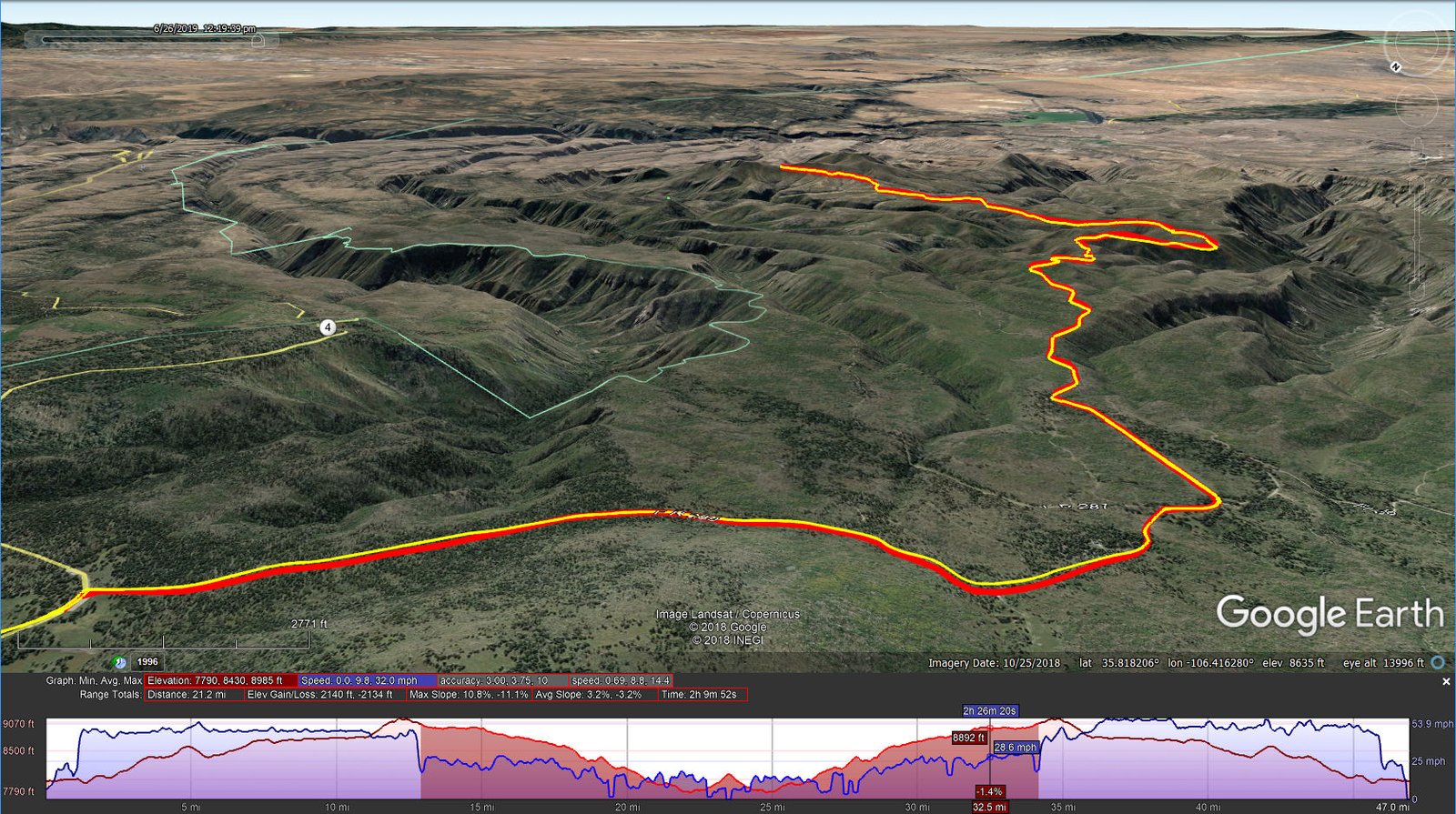
FR 289-St Peter’s Dome Driveabout.Pat.2019-06-26
We’ve developed a classification system for roads:
- Class 1 – paved in good condition
- Class 2 – paved but breaking up
- Class 3 – “New Mexico Paved”, graded sand or gravel in good condition
- Class 4 – ungraded, in good condition, typically a two-track (don’t go if not dry)
- Class 5 – a two-track but -not- in good condition (high clearance vehicle required, don’t go if not dry)
- Class 6 – good for hiking!
FR 289 is clearly a Class 3 – great condition even for a New Mexico Paved road (it had even been graded since our previous visit). There was one rocky, steep section with sharp drop off that gave us pause – to take it slowly and carefully. In the past, one could take FR 289 all the way to Cochiti Highway, down by Cochiti Reservoir. These days a gate at the boundary to the Cochiti Reservation prevents through traffic; when we were there “unofficial” signs so warned us.
Seven miles from NM 4 we turned left onto FR 142; this would be a Class 5 road – high clearance vehicle advised. FR 142 ends 3.5 miles from FR 289, ending with an immediate dropoff but a spot wide enough to turn around. From here a Class 6 two-track continues beyond a closed gate to the summit of St Peter’s Dome. On Google Earth I measure it to be 1 mile to the summit, from 8,118 to 8,460 feet elevation (342 ft gain); it is there waiting for us to return.
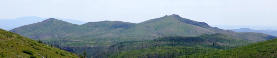
The view approaching St Peter’s Dome from FR 289; the dome has the two ‘bumps’ on its summit, the one to the right being a rock building lookout tower. Just visible as a line in the left center of the photo is FR 142 as it climbs up to the left on the northern slope of the Dome.
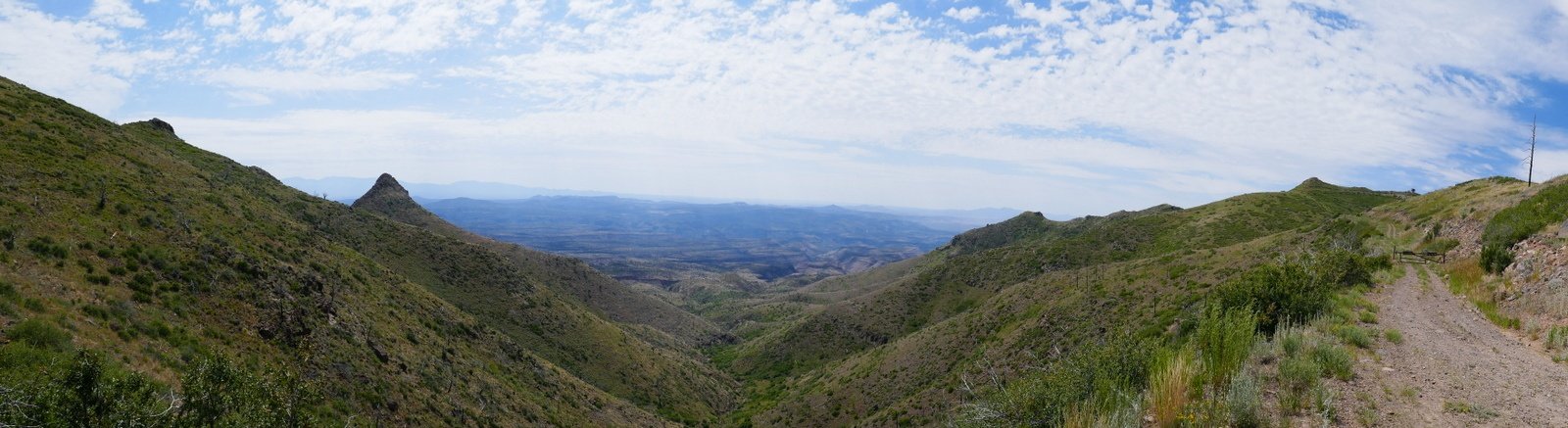
At the end of FR 142: To the left, Boundary Peak. To the right, the two track beyond the gate leading to the summit. In the center, across the Pajarito Plateau towards Bandelier in Frijoles Canyon, across the Rio Grande Canyon below White Rock, and the Sangre De Cristo on the horizon beyond Boundary Peak.
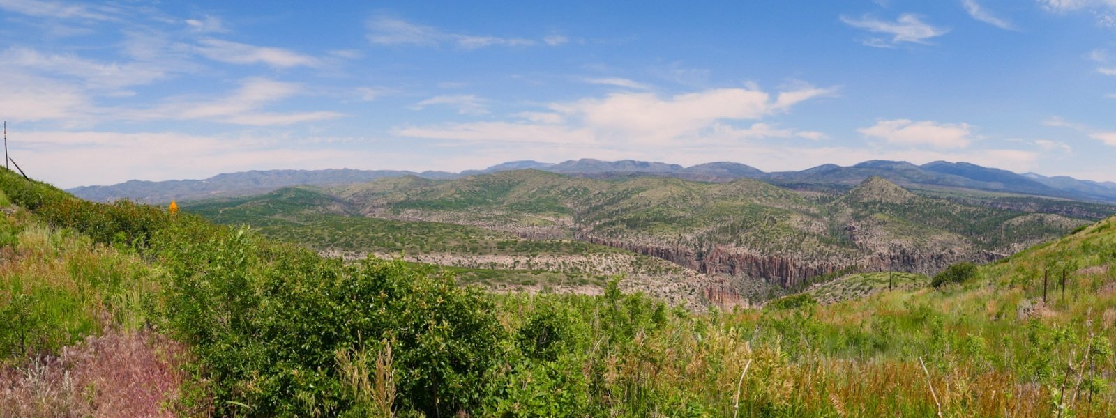
At the end of FR 142: Looking west across the deep canyons that slice through the San Miguel Mountains: Sanchez, Cochiti, Bland – very rugged terrain. And on the horizon to the right, the mountains of Valles Caldera.
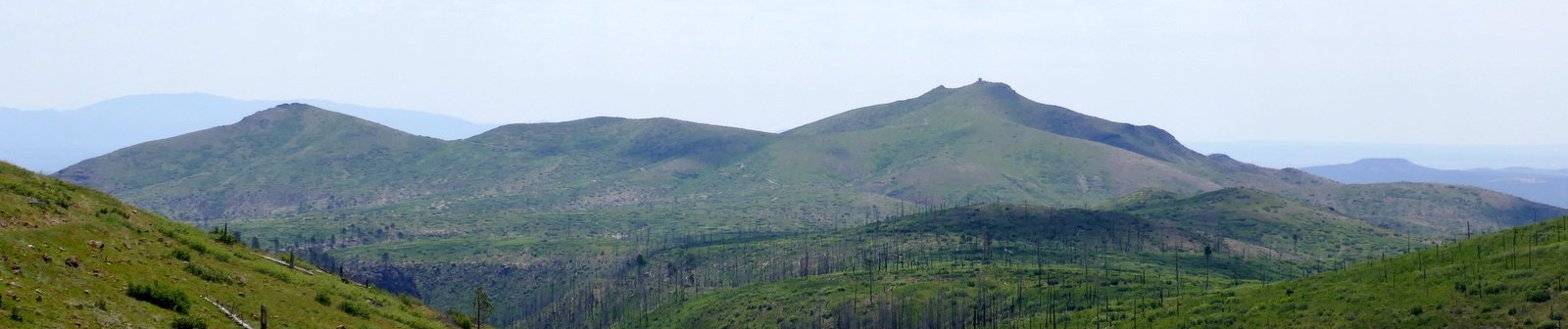
As the photos show, the mesas and cañons are denuded by fires, the Dome Fire in 1996 and the Las Conchas fire in 2011. Jay and I had visited the southern area of the Dome Wilderness back in 2016 (“Dome Wilderness, Sanchez Water Fall Hike – 9/25/2016“); the area was nearly devoid of plants. This year, at least in this northern portion of the Wilderness, plants are returning (especially this year with the snow and rain we’ve enjoyed).
As mentioned in our recent Alamo Spring hike, the absence of forest affords great views. The topo map depicts three trails that emanate from the parking place, the St Peter’s Dome trail going south, the Boundary Peak trail going east, and a third trail going north. Each connects with other trails in the Dome Wilderness or Bandelier National Monument. The canyons hereabouts are steep and deep, making such hikes daunting, but they must be quite scenic. Spending some time with Google Earth (including the EarthPoint Topo Map overlay), I can see some out-and-back hikes, and in one instance maybe even a loop of 5 or 6 miles going east of St peter’s Dome.
We look forward to returning, going to the summit of St. Peter’s Dome, and exploring these other trails. The track files below show our complete drive, from the Jemez Falls campground east on NM 4, then right on FR 289, St Peters Dome Road for 7 miles, then left on FR 142 (also St Peters Dome Road).
| GPS Track Files for Download | |
251 Downloads | |
|---|---|
208 Downloads | |
If you haven’t explored these hiking tracks with Google Earth, I urge you to try it. With the virtual 3-dimensional presentation, achieved by panning and tilting the view, you can get a much better idea of the hikes and terrain than you can get from the screenshot above. For some ideas, check out Using Google Earth Track Files.
References
(I’m including a wide range of references related to the Dome Wilderness; there is so much to explore. Other resources may be found for hikes starting from the Visitor’s Center of Bandelier National Monument.)
Forest Service:
St. Peter’s Dome Trail (just a brief description)
Wilderness Areas in the Santa Fe National Forest
AllTrails:
Saint Peters Dome Trail
Canada-Capulin Trail
Los Alamos NM: 50 Hikes in the Los Alamos Area (PDF)
Sangres.com: Dome Wilderness
SummitPost:
Dome Wilderness (an excellent overview, including list of features)
Saint Peters Dome WanderLust: Wanderlusting St. Peter’s Dome NM
Volunteers for the Outdoors: St. peter’s Dome Trail
Mountain Project: Capulin Canyon Rock Climbing
I wonder if a gate opening at Cochiti could be coordinated.
Good evening, Tommy. Are you hoping to find a way to go through between Cochiti and NM 4? I don’t know if that could be arranged. People that I have talked to have given me the idea that the Pueblo seems to discourage travel through their reservation. But I don’t know of anyone asking for their permission. If you pursue it, please tell me about your experience.
Thanks for asking, and I hope you are finding Hiking in New Mexico to be helpful for your hiking activities.