My brother, Garth, came to visit us for a week. After a few days of working together on the cabin (the usual excuse for him to come to New Mexico), on Sunday with Pat we headed to the Jemez Mountains and Valles Caldera for some cooler temperatures and the scenery. Checking in at the Visitors Center of the Valles Caldera National Preserve, we learned that the culvert that was washed out this past winter had been repaired and we could drive further into the Caldera – just what we were hoping for.
The Drive from Albuquerque to Valles Caldera
For those who haven’t visited this territory, here is a screenshot of the drive from home in Albuquerque to the entrance to the Valles Caldera National Preserve. It is an 81 mile drive, via I-25 northbound to Bernalillo (19 miles), then US 550 northwest bound to San Ysidro (23 miles). From there north on NM 4, through Jemez Pueblo, Jemez Springs, and La Cueva (26 miles), then to the entrance to Valles Caldera National Preserve (13 miles). To explore it further, download the GoogleEarth .KML file from the link below. [A note: don’t exceed the 30 mph speed limit in the Jemez Pueblo; their police are serious and enforce the limit.]
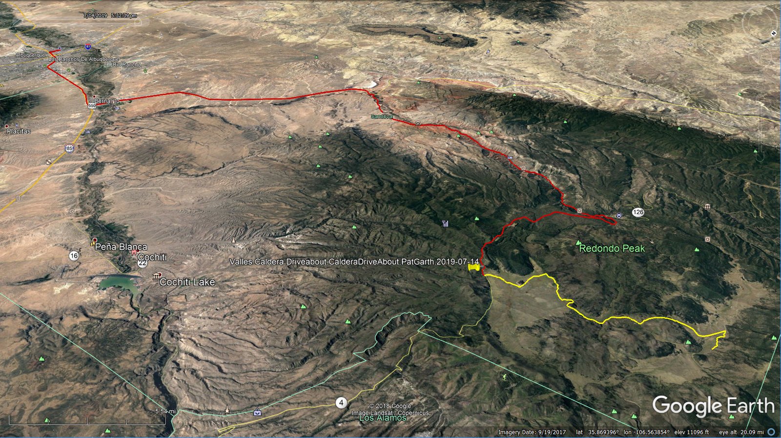
Valles Caldera Driveabout.PatGarth.2019-07-14
This drive itself is worth a day trip. After Bernalillo, the scenery is interesting ‘tho distant – White Mesa ahead, the red and rugged Mesa Cuchilla a bit to the right, and the Jemez Mountains off to the north. A few miles up NM 4 you will pass through the Jemez Pueblo (keep your speed below 30 mph), then a few more miles through Walatowa where the red cliffs dominate the view; the Walatowa Visitors Center is worth a visit. Along the way NM 4 follows the Jemez River with numerous parking areas for fishing (and a Forest Service campground – Vista Linda).
Leaving Walatowa and passing the Jemez Valley High School you will enter the narrow Cañon de San Diego with Mesa de Guadelupe and then Virgin Mesa on your left, and Mesa de las Casas and then Cat Mesa on your right, rising vertically from the Jemez River. NM 4 winds its way up the cañon to Jemez Springs, an interesting small village with restaurants, a truly old-time bar (Los Ojos), and a new tap room (Second Alarm Brewhouse, a “new-time” bar?). Continuing on NM 4 you will be climbing to higher elevations (and cooler temperatures), passing Soda Dam, more fishing spots, Battle Ship Rock, and … then on your right the tallest cliffs so far. Shortly you will reach La Cueva, really just a crossroad with a general store, and .. Nomad Mountain Pizza, where you will find a really great pizza (check online for their days and hours of business).
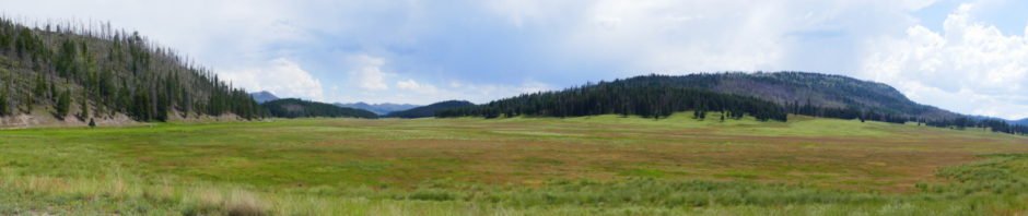
From La Cueva the climb continues – the road is ascending the southwest rim of Valles Caldera (La Cueva 7,800 ft, . About 5.5 miles from La Cueva you will make the first crossing of the East Fork Jemez River (in Cajete Cañon), and a half mile further trailheads for the East Fork Trail; the trail goes west towards McCauley Warm Springs, and east to the Jemez River Box – both make great hikes. From there the road takes you along the southern section of the rim and then down into into the Caldera. As you break out into the open, you will enjoy a grand view of Valle Grande – it is awesome. (Beware: the space of Valle Grande is so open and vast that it thoroughly confounds one’s sense of distances.)
(A note: I overheard a Forest Service Ranger at the Visitors Center point out that this Valle Grande -is only a small part the the Caldera. From NM 4 the distance to the far side of the Valle is only 4.3 miles to the north, 5.5 miles to the northeast. The diameter of the Caldera is more that 12 miles.)
The DriveAbout in Valles Caldera
As noted above, on our previous visits we weren’t able to drive past a washed-out culvert. Since then, repairs had been completed so we could drive into Valle San Antonio, the northern portion of the Caldera (screenshot below). Driving beyond the Visitors Center requires a pass and .. a promise to be back at the Center 30 minutes before closing (5:30 during regular summer hours). The road, VC01 from the Center then VC02 heading north, is well maintained (for a graded gravel road in New Mexico). It is certainly suitable for ‘street vehicles’ (high-clearance not required – just take it slow on the rocky and washboard sections). Again – distances are hard to judge – the drive from the Visitors Center to the junction with VC09 in Valle San Antonio will require 45 minutes or longer (important for planning, to as to be sure to return to the Center by 5:30).
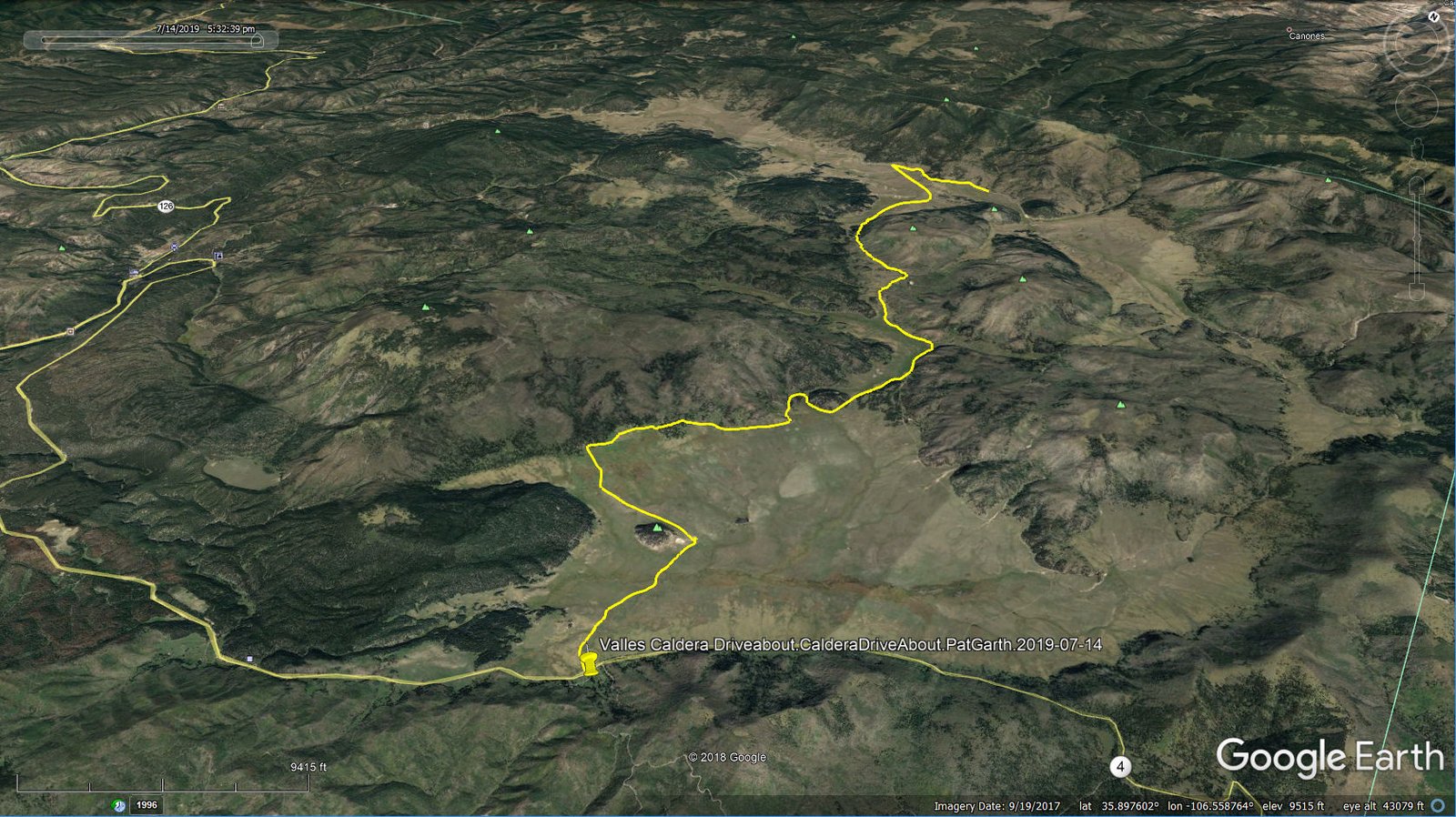
Valles Caldera Driveabout.CalderaDriveAbout.PatGarth.2019-07-14
The drive from NM4 is downhill all the way, but the view across the Valle is stunning. From here one can often see herds of elk out in the Valle – they appear so small because they are so far away. As you approach the Visitors Center, slow down for the Prairie Dogs.
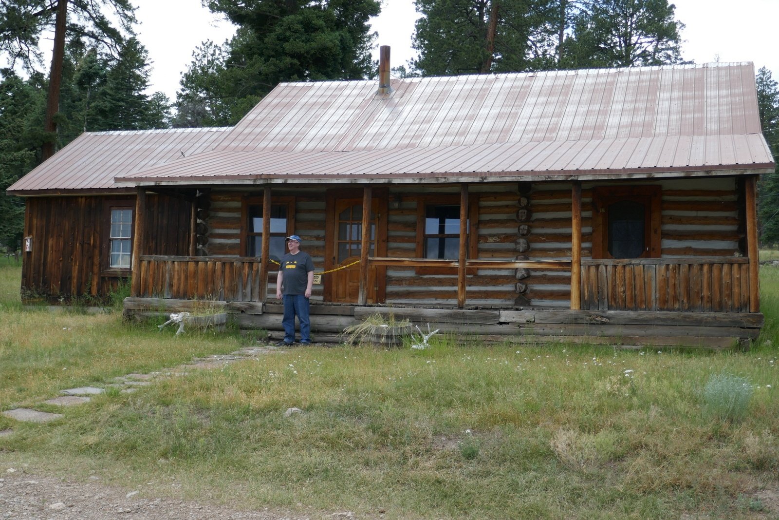 Driving west from the Visitors Center (again, drive slow, watch for the prairie dogs) you will enter the Cabin District, a collection of ranch buildings from the days when this was a working ranch. The Caldera has been the set for many movies and TV series, notable among them The Lone Ranger (2013) and Longmire (2012-2017). Garth is standing in front of the cabin that was the centerpiece for Longmire.
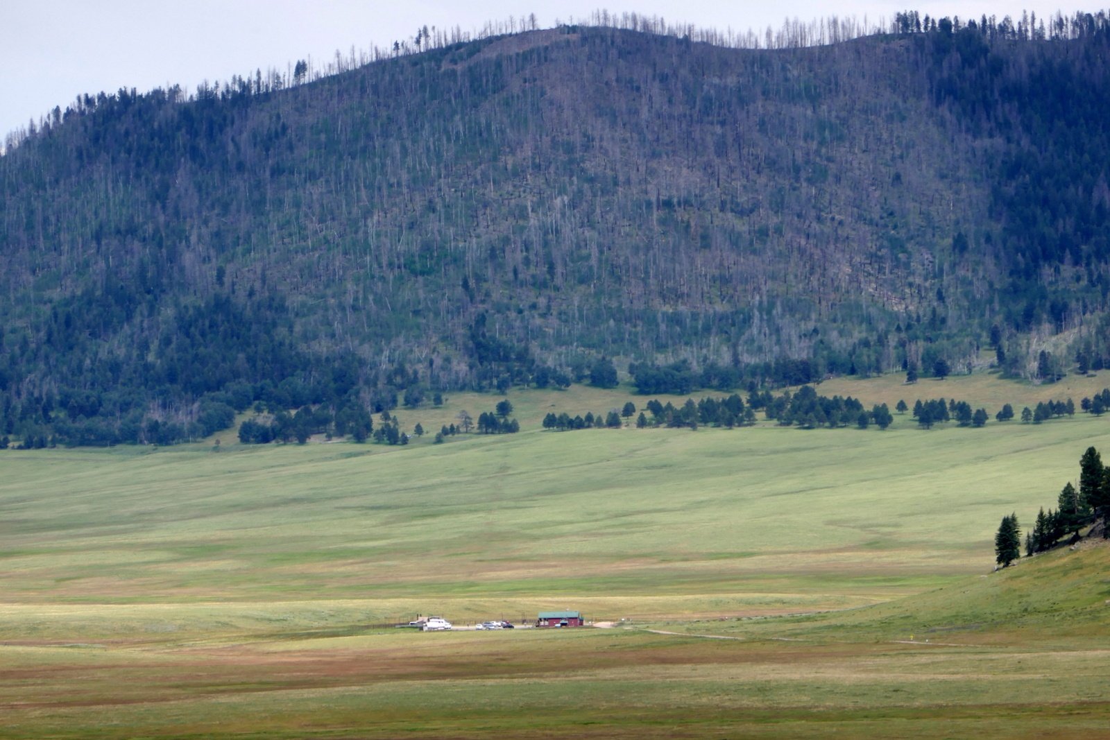
Proceeding north on VC02, the road gains elevation and the full extent of Valles Grande becomes apparent. The Visitors Center shrinks in the distance. Some 2 miles from the Cabin District, you will pass a road down to the Horse Corral. Then around a curve into Valle Jaramillo and across the Creek (same name); this was the washed out culvert.
Continuing on VC02 north in Valle Jaramillo between smaller mountains in the reserve, the view opens up again to the west. Jaramill Creek is bounded by lush grasses (and we have seen people fishing for trout in the creek. Some 6 miles further on you will enter into Valle San Antonio, much larger than Valle Jaramillo. Another mile or so you will come to a T in the road, with VC09 going east and west from this junction. We opted to go east, for just a short distance – time was approaching when we needed to head back to the Visitors Center before 5:30.
| GPS Track Files for Download | |
196 Downloads | |
|---|---|
221 Downloads | |
217 Downloads | |
224 Downloads | |
I urge you to explore our hiking tracks with Google Earth. With the virtual 3-dimensional presentation, achieved by panning and tilting the view, you can get a much better idea of the hikes and terrain than you can get from the 2-dimensional screenshot above. For assistance: Using Google Earth Track Files.
References
National Park Service:
Valles Caldera National Preserve
Maps
National Parks Traveler: Exploring The Parks: Valles Caldera National Preserve
Wikipedia: Valles Caldera
NM Museum of Natural History and Science: Valles Caldera, Jemez Volcanic Field
GeoTimes: A Secret Garden: New Mexico’s Valles Caldera
Facebook: Valles Caldera National Preserve
National Parks Traveler: Exploring the Parks: Valles Caldera National Preserve
BikePacking: Valles Caldera Supervolcano Explorer, New Mexico
(a superb photo gallery)
And check other posts for Valles Caldera
There is now a comprehensive trail guide to VCNP: Hiking Trails in Valles Caldera National Preserve, by Coco Rae. You can learn about it at https://vcnp-trails.com/.
Thank you, mtngrrl, for mentioning this great book. I have a copy, and in fact used it this week as a reference for our latest hikes while camping in the Jemez Falls Campground. Look for blog entries on these hikes in coming days. Happy Hiking.