Pat and I have hiked up Mount Taylor, last year and 2 years ago, and we were looking forward to doing it again. Jay and Nancy were intrigued and also wanted to ‘go the distance’. So we scheduled a 2-night camping trip, giving us a day to make the climb.
The Drive In
Because Jay & Nancy are tent-campers, we planned on camping in the Coal Mine Campground. Arriving there, we discovered that is not yet open for this year, But, Pat and I provided a fallback; from the 2020 Post:
“We had an easy drive to Grants, then through Lobo Canyon on NM 547 to FR 193 and on to our target campsite. The road has fresh, deep gravel (a Class 3 road) but the Tacoma/R-Pod handled it easily. We chose the campsite closer to the trailhead; an added benefit – it is  located on the edge of Lobo Canyon and thus affords better views than the other campsites. This, our first setup outside of an established campground, challenged us in maneuvering the R-Pod among trees and rocks to an area relatively level – great experience for future forays.”
The Hike
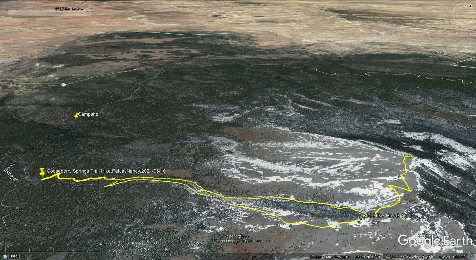
Gooseberry Springs Trail Hike.PatJayNancy.2021-05-10
The hike this year is much like Pat & I did last year, at least the ascent; I won’t repeat the description, but invite you to review that BLOG post. For the descent, we opted to follow the precedent of our first hike to the summit: descend on the trail to the tree line, then turn right to follow Gooseberry Creek down to it’s junction with the Gooseberry Spring trail.
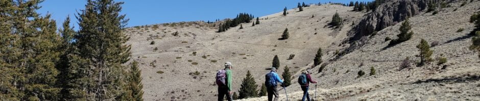
As we continue to embrace New Mexico’s vistas and features, we very much enjoyed the views from the many vantage points on the trail up Mount Taylor. The open forest through which we pass for the first half of the hike is so very pleasant, with the healthy aspen, ponderosa, and fir trees. Then above the edge of the trees, the views of the slopes ahead and along one section to the right are breathtaking. Out on the slope of the last half of the ascent the views to the west and south are wondrous. Topping out on the summit opens more views to the south and east.
Please step through the gallery of photos below to get a sense of what I’m trying to describe, and some descriptions of the hike.
Highlight
Inspecting maps closely, I had noted that the Continental Divide Trail (CDT) passed near our campsite. Then, a half mile into the hike a young woman caught up with us. It appeared by her pack that she was backpacking. Chatting briefly we learned that she had come from Grants and was in fact a through-hiker on the CDT. A half mile later, we caught up with her as she was chatting with Cheshire Cat (his trail name). He was introduced as a Trail Angel, well known by CDT through-hikers, particularly for providing ice cream sandwiches out on the trail. After a convivial conversation, the hiker continued ahead (being new at this through-hiking universe, we didn’t think to ask her trail name), and she was soon out of sight. Cheshire Cat headed back to the trailhead and his crazy-painted car (unfortunately, we didn’t think to take a picture of the car as we began our hike). And we continued on our way.
(Cheshire Cat challenged us with a $1,000,000 bet: who has right-of-way, a hiker going uphill or one going downhill? We all posited – uphill has right-of-way. He asserted that downhill has precedence, his logic being that one going downhill has difficulty stopping, particularly on a steep, rocky slope. ‘Tho that seemed to make sense to all of us, we continued to think – uphill. So I guess we have and IOU to him.)
As we were climbing up the switchbacks on the upper half of the ascent, we noticed another hiker gaining on us. A couple of hundred yards from the top, she caught up and went ahead. Upon arriving at the peak, she was there taking photos. We exchanged cameras to get ‘selfies’ to document our arrival. We invited her to join us while we had lunch, which she graciously agreed. We enjoyed great conversation, learning that her trailname is “No-No”, that she has been on the CDT for close to a month (starting at the US-Mexico border) and plans to finish at the Canadian border come September.
As we prepared to head back down, No-No told us we might encounter another through-hiker, trailname “Beer Goddess”. And .. as we returned to -the summit, a young woman was there taking her documentary photos. We may have surprised her, asking if she was Beer Goddess. Yes, she said, as we told her No-No was just ahead, packing up to continue on the trail. After getting a picture of her on her camera, we continued on our way, back down Mount Taylor.
Postscript
During our descent, we were reminded of our first hike on Mount Taylor back in 2018. Pat & I hiked to the saddle not far above the tree line. It was a great introductory hike and gave us perspective (and confidence) that we could hike to the summit. We returned two weeks later to ‘go to the top’. Reflecting on those experiences, and in conversation with Nancy & Jay, it occurred to us that others may hike to this half-way point, a bit more than half way in distance and half way in elevation gain. Such a hike would not be so strenuous and would give one great views all around, especially the last 1/4 mile along the east side of the ridge, with a beautiful view across Rinconada Canyon. Then descend, as we did, down into Goosberry Canyon, back to the Trail and to the trailhead.
Statistics
Total Distance: 6.31 miles
Elevation: start 9,275 ft, maximum 11,309 ft, minimum 9,275 ft
Gross gain: 2,034 ft. Aggregate ascending 2,246 ft, descending 2,247 ft
Maximum slope: 40% ascending, 41% descending, 12.8% average
Duration: 6:44
| GPS Track Files for Download | |
167 Downloads | |
|---|---|
147 Downloads | |
If you haven’t explored these hiking tracks with Google Earth, I urge you to try it. With the virtual 3-dimensional presentation, achieved by panning and tilting the view, you can get a much better idea of the hikes and terrain than you can get from the screenshot above. For some ideas, check out Using Google Earth Track Files.
Related Posts
Gooseberry Springs Trail Hike – 06/10/2020
Gooseberry Springs Trail Hike #2- 06/13/2018
Gooseberry Springs Trail Hike – 06/01/2018
References and Resources
See References and Resources for the 2020 hike
Through-Hikers APP: GutHook Guides
Hiking Dude: Continental Divide Trail (download .kml file)


