We returned to Mount Taylor where Pat & I made two hikes two years ago (a reconnoiter hike followed two weeks later by a hike to the summit). As then, we took our R-Pod camper for two nights giving us a whole day to make the hike without traveling. As for camping, since the Coal Mine Campground was closed, we made a one-day trip a week ago to locate a suitable campsite where the Forest Service permits “dispersed camping”. We found more than a dozen such sites; checked 3 or 4 of them to determine suitability for bringing in the R-Pod (care taken to avoid branches that might snag the camper); we marked 2 that we judged to be suitable.
Drive In and Camp Setup
We had an easy drive to Grants, then through Lobo Canyon on NM 547 to FR 193 and on to our target campsite. The road has fresh, deep gravel (a Class 3 road) but the Tacoma/R-Pod handled it easily. We chose the campsite closer to the trailhead; an added benefit – it is  located on the edge of Lobo Canyon and thus affords better views than the other campsites. This, our first setup outside of an established campground, challenged us in maneuvering the R-Pod among trees and rocks to an area relatively level – great experience for future forays.
The Hike
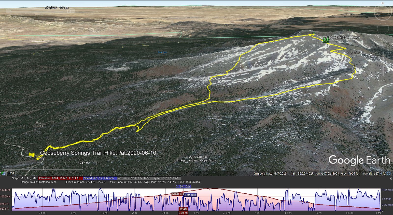
Gooseberry Springs Trail Hike.Pat.2020-06-10
After a pleasant night (‘tho chilly – a cold front brought night time temperatures into the low 40s – the extra blanket was welcome as was the heater in the early morning – but .. cooler temperatures were promised for the hike), we drove the two miles or so to the trailhead and set off. The first half of the trail is quite pleasant, wending through open forest of mostly ponderosa pine. The trail itself “gets with it quickly”, enough slope to get blood moving and breathing heavy. In places the surface is a bit rocky, in other places it’s dirt with pine needles that soften the footfall.
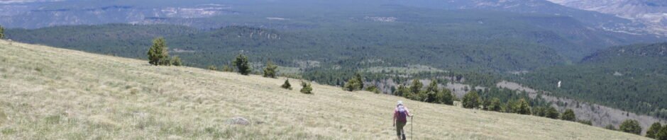
As we left the forested portion of the  trail, we stopped to recharge with Instant Ramen Soup. The 2nd half to the summit is in the open; we again enjoyed the magnificent views to the east, south, and west. (See more descriptions from our previous hike to the summit.) At the summit, we relaxed a while with coffee & hot chocolate and peanut butter & jelly sandwiches.
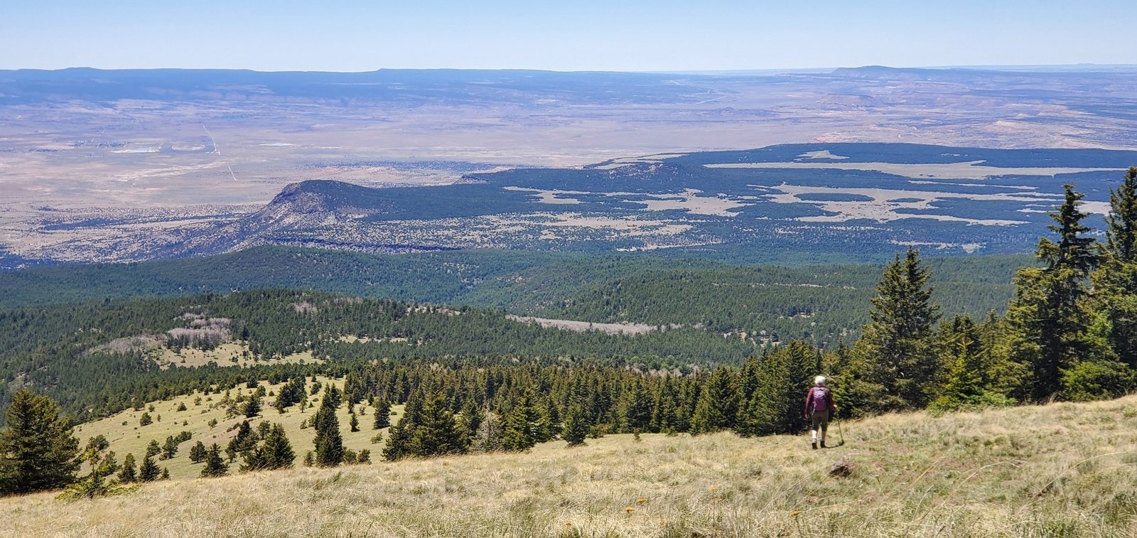
Because of the rocky surface on the last 1/4 of the trail, we opted to take a different route back down the mountain. AllTrails showed a track that went north from the summit, then west and south to make a loop back to the trailhead (Gooseberry Springs and Mount Taylor Loop). The AllTrails map also showed a dotted line down the west slope – we chose to take that ‘shortcut’. It proved to be a seldom-used two track that was not too steep – ’twas a good choice. Where this two track intercepted the AllTrails track, we chose to make a more direct route towards the trailhead by descending down the wide open grassland. The slope of the terrain was fine (for descending) and covered with thick grass. We used this opportunity to gain some experience in interpreting the topo maps versus ‘ground truth’. We sought a track with lesser slopes and one that didn’t require any climbs up from the intervening valley.
Overall we were successful, descending a uniform slope, then tracking a topo line where it was necessary to ascend up to a ridge . For the last 100 or so feet of elevation, we found cattle trails that made the descent easier (cattle figure out how to ‘bushwhack’). Easier .. until the final 50 feet or so of really steep slope and thick bushes that made for real ‘bushwacking’.
Before leaving this descent, we reviewed the topo map to identify a route down that might be easier on a future hike to the summit. The remainder of the hike, down Lobo Canyon past Gooseberry Springs and to the trailhead was most pleasant. Back at the campsite we had a very nice evening, slept well in the camper, and enjoyed a relaxing morning at the campsite. Heading home, on our way out of Grants we recalled on our last visit having a pleasant break at the Route 66 Junk Yard Brewery. Stopping there would have been a very nice, but since breweries have been closed due to Covid-19 we pressed on to Albuquerque. Note: We had cellphone service at the campsite and for most of the hike. This permitted us to check out AllTrails and other sources for alternative ideas.
Statistics
Total Distance: 6.0 miles
Elevation: start 9,274 ft, maximum 11,314 ft, minimum 9,274 ft
Gross gain: 2,040 ft. Aggregate ascending 2,274 ft, descending 2,274 ft
Maximum slope: 39% ascending, 43% descending, 13.6% average
Duration: 8:33
| GPS Track Files for Download | |
176 Downloads | |
|---|---|
311 Downloads | |
If you haven’t explored these hiking tracks with Google Earth, I urge you to try it. With the virtual 3-dimensional presentation, achieved by panning and tilting the view, you can get a much better idea of the hikes and terrain than you can get from the screenshot above. For some ideas, check out Using Google Earth Track Files.
References and Resources
US Forest Service: Gooseberry Springs Trail
Gooseberry Springs Trailhead
SummitPost: Mount Taylor
AllTrails: Gooseberry Springs and Mount Taylor Loop
Mount Taylor via Gooseberry Trail
ondafring: Day Hike: Mount Taylor
ASCHG: Mount Taylor From Gooseberry Spring Hike
Stav is Lost: Hike Mt. Taylor via Gooseberry Springs Trail (great photos)
Four Corners GeoTourism: Gooseberry Springs Trail – Mt. Taylor
Outdoor Project: Gooseberry Springs Trail to Mount Taylor
Hiking Project: Gooseberry Trail


