Earlier this summer, I came across descriptions of hiking in the Dome Wilderness, a small designated wilderness area abutting the western boundary of Bandelier National Monument; it looked intriguing. With the cooler temperatures of autumn, and a willingness to go further into the wilderness on barely improved Forest Roads, we headed for the trail (see references below).
The Drive In
The drive was itself interesting: past the Cochiti Pueblo and Cochiti Dam and Lake, and the Town of Cochiti, onto Forest Road 89, then 289 (a high clearance vehicle, preferably with 4-wheel drive is recommended but not necessary). The trailhead was easy to find, with a nice parking area for a half dozen cars.
The Hike
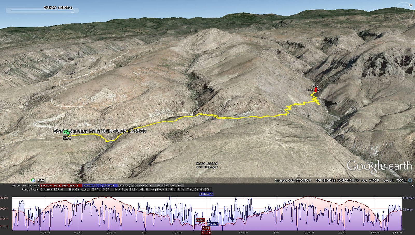
Google Earth screenshot of hike on Trail 118 across Eagle Canyon to Sanchez Canyon and the Sanchez Waterfall. We could not see a way to get down into Sanchez Canyon below the waterfall, so we had coffee on the canyon above it.
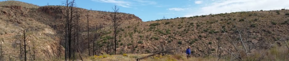
About 100 yards from the trailhead, we are looking down into a steep sided, narrow, fairly deep canyon – this made us wonder if this is going to be a difficult transit. It wasn’t – the trail has switchbacks so it is never steep; the surface is rocky, but not loose rocks, which makes for good footing and easy walking. As you can see from the screenshot, there are no (live) trees. Two fires have burned through the Dome Wilderness, the Dome Fire in 1996 and the Las Conchas fire in 2011. As you can see in the photos, there are many blackened trunks, standing and fallen, and only a few scrub oaks growing. But … there were lots of colors in the many different flowering plants scattered throughout the area.
Up out of Eagle Canyon across the adjoining mesa, then along the west slope of Sanchez Canyon. The trail here is carved out on the very steep side of the canyon; the trail isn’t narrow, but the steep falloff into the canyon can be unnerving. The presence of a waterfall was first signaled by the noise of falling water. The trail crosses the canyon above the waterfall, and there was no way safe for us to see the waterfall from there. It was only on the way out that we sighted the stream of water down deep in the canyon.
We walked some 100 yards up the canyon and found some shade afforded by fallen tree trunks and debris washed down the canyon. It was here we had our traditional mid-hike refreshments, and a bit of rest and relaxation before heading back to the Tacoma.
On the way out, we explored FR 89, which goes further north from the intersection with FR 286. Tho’ a bit rough (high clearance recommended), we found ourselves among fruit trees, and at the end of the road. We drove past a quonset shelter filled with boxes used for transporting fruit, and found them labeled “Dixon Orchard”. Maybe this is the Dixon Orchard, popular over many years until the Conchas Fire wiped it out.
Statistics
Total Distance: 2.95 miles
Elevation: 6,600 start, 6,692 maximum, 6,470 minimum
Gross gain: 222 ft. Aggregate ascending 1,127 ft, descending: 1,128 ft
Maximum slope: 59% ascending, 66% descending, 11% average
Duration: 2:44
| GPS Track Files for Download | |
255 Downloads | |
|---|---|
798 Downloads | |
I urge you to explore our hiking tracks with Google Earth. With the virtual 3-dimensional presentation, achieved by panning and tilting the view, you can get a much better idea of the hikes and terrain than you can get from the 2-dimensional screenshot above. For assistance: Using Google Earth Track Files.
References
USFS Santa Fe National Forest, “Wilderness Areas in the Santa Fe National Forest”
From Albuquerque Journal, July 1998: “Sanchez Canyon”
ASCHG Hike “Base Of Cerro Picacho Hike”, 2/6/2015
Summitpost “Dome Wilderness”
Excerpt from “New Mexico Wilderness Areas; the Complete Guide”
From Doug Scott Art, Photo of Sanchez Falls from below


